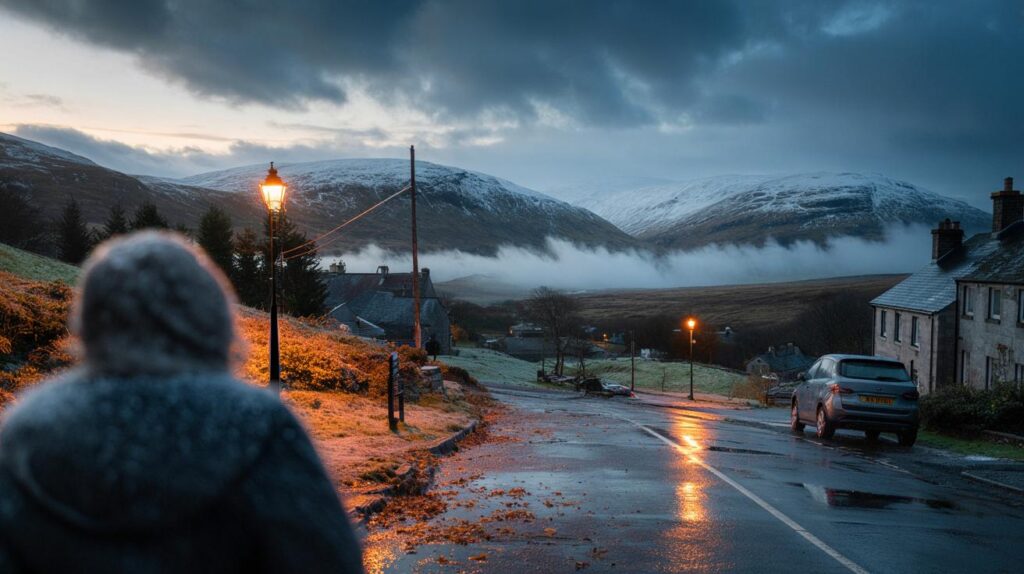
Cold air edges closer as Atlantic fronts shuffle east, leaving Highland tops eyeing early flakes and commuters checking weekend plans.
Forecast maps now paint a colder, more changeable picture for the second week of October. High ground in Scotland sits in the firing line first, while eastern districts turn wetter and windier. Towns further south stay mild by night, but a nip in the air creeps in by day.
Where snow is most likely
Scotland: Cairngorms in the frame
Model output highlights the Cairngorms as the first place to watch. A patch of intense colour on chart overlays centres over the national park. Timing points to Sunday 12 October, when colder air brushes the Highlands.
WX Charts signals around 7.3 cm on the Cairngorms within the day on Sunday 12 October, focused on the highest slopes.
Any accumulation favours summits and windward ridges. Lower glens lean to cold rain or sleet. Gusty winds may blow snow off ridgelines and cut visibility. Hillwalkers should expect rapid changes, with showers turning wintry above roughly 800–900 metres.
England and Wales: only the loftiest peaks
The Lake District, the Pennines and Eryri/Snowdonia sit on the margins. Air aloft cools, but sea-influenced air near the surface stays relatively mild. Brief wet snow over the very highest tops cannot be ruled out if showers turn intense. Fells and moors below summit level look set for rain or sleet.
How much and when
The headline number doing the rounds is 2.8 inches. That matches about 7.3 centimetres on model charts for the Cairngorms. The signal concentrates over a single day, not a prolonged event. Bursts could be sharp, then ease away as pressure nudges up from the west.
The 2.8-inch figure reflects modelled daily accumulation on the highest Scottish peaks, not a guaranteed hourly rate everywhere.
Expect the window to open from late Saturday into Sunday as winds swing more north-westerly in the wake of passing fronts. The risk lingers into Monday on the tops if colder pockets persist. Eastern coasts turn shower-prone as the pattern pivots, while western Scotland finds drier slots later.
What the Met Office says
The official long-range guidance keeps a westerly flavour at first, with relatively mild nights under cloud and rain bands arriving from the Atlantic. Stronger winds favour northern and western hills with frequent spells of rain or drizzle. Eastern counties see longer dry breaks.
Towards the weekend of 11–12 October, pressure builds to the west or southwest. Lower pressure nudges in to the east. That shift pushes the wet and breezy weather towards the east and southeast. The west and southwest gain the best of the dry interludes. Within that pattern, a slightly cooler phase develops, opening the door to wintry showers on the highest Scottish ground.
At-a-glance risk by region
| Region | Elevation most at risk | Timing window | Likelihood | What to expect |
|---|---|---|---|---|
| Cairngorms (Scotland) | Above 800–900 m | Sun 12 Oct (into Mon) | Moderate | Snow showers; modelled total near 7.3 cm on highest tops |
| Northern Highlands and Grampians | Above 800 m | Sun–Mon | Low to moderate | Patchy wet snow in heavier bursts, otherwise sleet and rain |
| Lake District fells | Above 850 m | Sun | Low | Brief sleet or wet flakes on summits; rain lower down |
| Pennines | Above 700–800 m | Late Sun | Low | Cold rain with isolated wintry bits on the highest moors |
| Eryri/Snowdonia | Above 900 m | Sun night | Very low | Isolated wet snow on the tops in a heavier shower |
| Lowland towns and cities | Below 300 m | All period | Very low | Rain or drizzle, breezy at times |
Travel and power: what to do now
Hills and passes may turn slushy for a time if showers line up. Blustery conditions could bring brief crosswinds on exposed bridges and cause spot flooding in heavier downpours. Energy demand rises as temperatures dip by a few degrees.
- Check mountain forecasts before setting out; carry layers, spikes and a headtorch.
- Plan for slower routes across high passes; keep fuel above a quarter tank.
- Secure loose garden items ahead of stronger gusts in the east and northeast.
- Allow extra time for rail journeys where leaf-fall and wet rails affect braking.
- Keep phones charged; note local power cut helplines in case of brief outages.
Why high ground sees snow first
Air cools with height. On a showery north-westerly, moist air is pushed up over mountains. Rising air cools, cloud deepens and precipitation intensifies. If the wet-bulb temperature near the summit falls to freezing, snow forms even while lower valleys see rain. Wind then redistributes the snow, creating deeper drifts on lee slopes and scouring windward faces.
Sea surface temperatures moderate coastal air. That keeps coastal towns milder and reduces the chance of snow at low levels this early in the season. Inland glens can still turn chilly at night under clearer skies once fronts move through.
Reading the charts without the jargon
WX Charts display raw model output. Colours indicate forecast precipitation type and intensity at a given hour. A patch of purple over the Cairngorms signals a wintry mix or snow on the highest land. That does not guarantee ground-level snow. It points to a risk window for the summits when air aloft cools enough.
Use model maps as guidance on timing and intensity, then lean on official forecasts for local detail and impacts.
The Met Office outlook describes the broader pattern. A westerly flow keeps nights less chilly under cloud, but a nudge towards higher pressure to the west and lower pressure to the east often invites cooler north-westerlies. That setup favours eastern showers and drier, brighter breaks in the west and southwest.
What to watch next
Keep an eye on how quickly pressure rises to the west. A stronger ridge would cut off showers sooner and trim snow potential. A slower build would prolong the showery phase into Monday on Scottish tops. Watch the wind direction: a more northerly tilt enhances wintry showers across the northern Cairngorms; a more westerly flow keeps things milder and wetter.
Small temperature changes aloft make a big difference. If 850 hPa temperatures dip a degree or two further than modelled, snowline drops and showers become more widespread over the highest ground. If they verify higher, accumulations will be patchier and short-lived.


That “2.8 inches an hour” headline feels misleadng. The article says it’s a modelled daily total on the highest Cairngorm tops, not an hourly rate. Maybe clarify before folks start panic-posting?