A flicker of winter teases the forecast maps as a mid-October shake-up gathers pace across the north of Britain.
Computer models now flag bursts of heavy snow for the Scottish high ground, with timing focused around 18 to 19 October. Early signals point to short, intense spells rather than a widespread blanket, yet the rates modelled could prove disruptive on the hills.
Where the first flakes may fall
Advanced runs of the GFS, visualised by WX Charts and echoed on Ventusky, push a wedge of colder upper air into Scotland in the third week of October. That colder pool collides with moist Atlantic air and upslope flow over the Highlands, setting the stage for wintry showers on the highest routes and peaks.
The areas currently highlighted lie from the central Highlands to the far north-west. Town names on the maps include Perth and Inverness as reference points; the most persistent showers are signalled farther north and west across Ross and Cromarty, especially over elevated ground.
Model snapshots suggest brief surges of snowfall intensity up to 5cm per hour on higher ground between 18 and 19 October.
Counties flagged by the modelling:
- Perthshire
- Inverness-shire
- Ross County
- Cromartyshire
At low levels, rain looks more likely than settling snow. The risk zone tightens rapidly with height, with the Cairngorms, the Monadhliath and hills around Ben Wyvis most exposed to strong orographic forcing. Any snow to lower ground would be highly localised, short-lived, and dependent on the timing of the coldest air.
How likely is settling snow?
Ground temperatures remain seasonally mild after a run of damp, cloudy spells. That keeps roads relatively warm, so the first showers may struggle to stick below 400–600 metres. Where showers bunch and intensify, and where surface temperatures dip overnight, slushy coverings are plausible on passes and upland tracks. If the 5cm per hour rates verify on ridges, mountain paths could whiten quickly during heavier bursts.
Expect rain at most elevations, with wet snow or sleet above roughly 400–600 metres and the most credible accumulations confined to the highest tops.
What the Met Office says for mid-October
The official line for 8 to 17 October points to a broadly westerly pattern. That keeps nights relatively mild to start, with fronts drifting in from the Atlantic. Northern and western areas look more prone to spells of rain or drizzle; the east fares drier between bands of cloud. As the 11–12 October weekend approaches, pressure builds from the west or south-west, bringing lighter winds and a calmer feel for many. Fog becomes a growing risk where skies clear at night, and a nudge of cooler air may edge in later as breezes turn easterly.
From settled to unsettled: a swift pivot
From 18 October into the final days of the month, guidance turns back towards a more unsettled regime. Whether this arrives via quick-fire Atlantic systems or a slower-evolving pattern is still up for debate. Either way, more locations are likely to see frequent rain or showers, with a chance of strong winds at times. Temperatures hover near the seasonal average.
Timeline at a glance
| Date window | Region | Elevation most at risk | Possible peak rate | Confidence |
|---|---|---|---|---|
| 8–12 Oct | UK-wide | — | Rain or drizzle in west | High |
| 13–17 Oct | Most areas | — | Settled spells, fog risk | Medium |
| 18–19 Oct | Scottish Highlands | Above 400–600m | Snow showers up to 5cm/h | Low–medium |
| 20 Oct–1 Nov | UK-wide | Highest tops only | Showery, windy at times | Low–medium |
Travel and daily life: what you should plan for
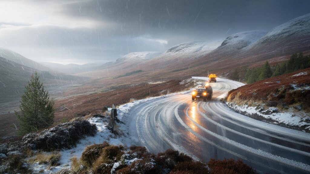
Heavy but brief snow showers can create sharp contrasts over short distances. A sunny glen may sit next to a hill road covered in slush. If you live or work near the Highlands, small, simple adjustments help you avoid nasty surprises.
- Check nowcasts close to the day, as shower tracks shift quickly in showery set-ups.
- If crossing high passes, allow extra time and carry warm layers, a torch and a phone power bank.
- Expect strong gusts on exposed ridges; wind chill bites harder once showers turn wintry.
- Cyclists and walkers should plan lower routes if cloud bases drop and paths become slick.
- Drivers may face brief, intense squalls: slow before bends and avoid harsh braking on slush.
On upland routes, a burst near 5cm per hour can turn wet tarmac to a slushy layer in 30 to 60 minutes.
Why models point to northern Scotland
Two ingredients stand out. First, a tongue of cooler air aloft brushes northern Scotland as the mid-month pattern flips. Second, strong, moist westerlies funnel into the Highlands. When that flow is forced up over terrain, clouds thicken and showers intensify. This “orographic” lift squeezes out extra precipitation, and if freezing levels are low enough, the result is snow on summits while valleys take rain.
Charts from WX Charts, derived from the GFS model, and mirrored by Ventusky, capture these signals with broad strokes. They show location and timing risk, not precise street-level outcomes. The most eye-catching detail is the potential snowfall rate: a high-end, short-duration burst, not an all-day blizzard.
What this means if you live outside the Highlands
For most of the UK, mid-October still reads as classic autumn: showers, breezes and occasional bright gaps. Eastern counties may steal the driest hours between fronts. The main nationwide shift comes later in the month, when more frequent rain and some windy interludes become possible. Temperatures near average keep frost limited, though clearer nights could allow local fog patches to form, notably in rural dips.
If you are heading north for work, sport or a weekend drive, treat the 18–19 October window as changeable. Plan around the likelihood of rain at low levels and mixed wintry showers above the 400–600 metre band. Lower towns such as Perth and Inverness sit on the edge of this story, acting more as markers on the map than guaranteed snow spots.
Extra context for the curious
Snowfall “rate” differs from “accumulation”. A shower could peak at 5cm per hour for ten minutes, leaving less than a centimetre once it passes. Accumulations reflect intensity, duration, surface temperature and compaction. Early-season snow compacts quickly on warm ground and melts from below, so totals often look modest unless showers chain together.
Confidence improves within 48 hours of the event as higher-resolution models focus on the Highlands. Watch for updates on freezing levels and wind direction; a 1–2°C nudge in the 850 hPa temperature or a slight wind shift can lift or lower the snow line by hundreds of metres.


5cm per hour sounds dramatic, but modles flip-flop every other day.
So it’s ‘whiteout’ for the hills and ‘wet-out’ for the rest of us? Guess I’ll pack sunglasses and snow chains just in case 🙂