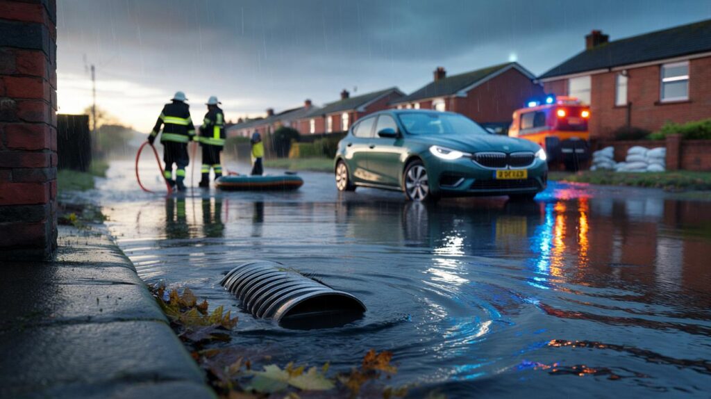
Sirens sounded, pumps buzzed and neighbours scrolled their phones as dawn broke over sodden pavements after a long, waterlogged night.
Relentless rain soaked the north-west for more than 20 hours, bringing dozens of flood warnings, snarled roads and street-level drama. As water climbed drains and kerbs, drivers abandoned cars, crews ferried sandbags and night-shift rescuers pulled people from rising waters.
Twenty hours of rain across the north-west
Downpours swept Greater Manchester, Cheshire, Merseyside and Lancashire from Saturday morning into Sunday. The Environment Agency issued 28 flood warnings at the peak, with dozens more alerts advising people to take action. The Met Office placed the region under a yellow warning for heavy rain from 09:00 BST Saturday to 06:00 BST Sunday, signalling a high chance of travel disruption and localised flooding.
Twenty hours of near-constant rain triggered 28 flood warnings and left sections of the region impassable.
The impact varied by street and slope. Low-lying roads in Altrincham and Salford saw water pooling bonnet-high in places. A major standby incident was declared in Warrington as drains struggled to cope, before being scaled back once levels eased.
Rescues before sunrise
Greater Manchester Fire and Rescue Service helped three men to safety at about 04:00 BST in Swinton, Salford, after their vehicle became stuck in fast-rising water. Crews also checked culverts and drains as callers reported blocked gullies and water backing up near junctions.
Three men were brought out of a flooded vehicle at around 04:00 BST as waters rose in Swinton.
By late Sunday morning, the Environment Agency had lifted all warnings as levels dropped. Debris and standing water still slowed travel in places, and recovery teams continued to move vehicles that had been stranded overnight.
Where the water went and who felt it most
Warnings spanned a wide area. In Greater Manchester they covered parts of Trafford, Stockport and south Manchester. In Cheshire, focus fell on Warrington and nearby Penketh, where residents watched water flow downhill and spread across carriageways. Merseyside saw alerts for parts of Liverpool and the Wirral. Lancashire’s alerts included areas near the River Darwen in Ewood and Waterfall in Blackburn.
| Location | Reported issue | Current status |
|---|---|---|
| Altrincham | Cars struggled through pooled water on residential streets | Water receded by late morning; debris still on roads |
| Swinton, Salford | Vehicle trapped in rising water; three people assisted | Rescue completed; monitoring of gullies ongoing |
| Penketh, Warrington | Roads flooded as drains became overwhelmed on a downhill stretch | Pumps and sandbags deployed; levels easing |
| Causey Bridge, Sankey Brook | Water rose to within 10cm of overtopping around 08:00 BST | Levels subsiding by mid-morning |
| Liverpool and Wirral | Handful of flood alerts for surface water and watercourse response | Alerts later lifted as rain moved away |
| Ewood and Blackburn | Alerts near the River Darwen and Waterfall | No significant property flooding reported by midday |
Street-level pressure on drains
Residents in Penketh described water pouring down gradients and overwhelming gullies. A councillor arranged for a pump to shift the worst of the pooling. People there say short bursts of heavy rain often create a temporary “lake” at the bottom of their road, and Saturday’s long-lived downpour magnified the effect. The scene was repeated on other low-lying streets where autumn leaves and litter narrowed the gap between drains and rising water.
Steep streets and clogged gullies amplified flooding as water rushed to the lowest points faster than drains could carry it away.
Sandbags made their way to doorsteps in the most exposed spots, with neighbours forming lines to protect thresholds and garage doors. Warrington South MP Sarah Hall urged residents to stay alert as levels rose and then steadied, recognising the anxiety felt by families who had seen floodwater at their doors before.
What the warnings meant — and what they did
The Environment Agency issues three escalating categories in England:
- Flood alert: flooding is possible. Be prepared to act.
- Flood warning: flooding is expected. Take action to reduce damage.
- Severe flood warning: danger to life. Follow emergency advice immediately.
Saturday’s picture included a mix of alerts and warnings. Warnings triggered practical steps: moving vehicles off kerbs, lifting electrics and valuables, and placing flood boards and sandbags at entry points. The message reached people quickly through apps and local channels, prompting early action that reduced losses in several streets.
Travel, schools and businesses
Burst water on carriageways slowed buses and closed short sections while teams assessed manholes and culverts. Delivery drivers rerouted around side streets where cars had been abandoned nose-out on verges. Small businesses moved stock to higher shelves and delayed opening until water retreated.
- Drivers faced reduced visibility and spray, with extended braking distances on dual carriageways.
- Rail services ran, but with speed restrictions in places where water neared the track bed.
- Bin collections slipped on some rounds as wagons avoided submerged junctions.
Why these downpours hit so hard
Long-duration rain saturates ground and fills watercourses. Once soils near capacity, each new burst runs off faster, which pushes water downhill to roads and basements. Urban areas react quickly because tarmac and paving shed water rather than absorb it. Leaves in early autumn add another pinch point, matting over drain grates. Where a brook sits behind a culvert, a few centimetres can decide whether a path stays damp or ends up knee-deep.
Only 10cm separated Sankey Brook from spilling at Causey Bridge, a reminder that small margins matter during long wet spells.
Yellow warnings from the Met Office indicate a likelihood of disruption, not certainty of damage on every street. The weekend’s pattern matched that picture: dozens of communities stayed clear, while a cluster of known hotspots felt the strain.
What to do if your street sits low or near a brook
- Park on higher ground before heavy rain arrives to avoid flooded electrics and intake damage.
- Check drains outside your home and clear leaves from grates where safe to do so.
- Keep a small kit ready: torch, phone power bank, work gloves, plastic sheeting and duct tape.
- Move plugs, extension leads and small appliances off floors in ground-floor rooms.
- Do not drive through standing water deeper than the centre of your wheel; water can stall engines and hide hazards.
After the water drops: hidden risks and next steps
Receding water leaves grit, oil and bacteria on surfaces. Footpaths stay slick, and manhole covers can shift. Wash boots and tools after contact with floodwater and keep pets away from puddles. Photograph any damage before clean-up and note times and depths; this helps with insurance. If a vehicle inhaled water through its intake, avoid starting it and call recovery to prevent further harm.
Councils tend to prioritise known choke points for leaf clearance during wet spells. Residents can request gully checks and report repeat flood spots. In streets like Penketh’s downhill stretch, small changes help: kerb-side leaf bags, permeable driveways and cleared culvert mouths increase the odds that the next cloudburst drains away faster.
Looking ahead
While all warnings ceased by late Sunday morning, forecasters will track further bands of rain during the week. Soils remain damp after a full day of wet weather, which means less capacity to absorb fresh showers. People living near brooks or at the bottom of slopes should keep an eye on local updates and prepare simple defences. A few minutes spent moving a car or lifting cables can spare hours of clean-up when the next band arrives.


Useful breakdown, but when do councils actually invest in upstream fixes, not just sandbags? Penketh’s downhill “lake” happens every squall because gullies clog and tarmac shunts runoff straight to the low point. Permeable driveways, kerb‑side leaf bags, and clearing culvert mouths are mentioned here — great — yet budgets keep getting raided. They definately help. Can the Environment Agency and councils publish a public schedule for gully sweeps and known choke points? Also, what are the thresholds for a “major standby incident” in Warrington — seems a bit opaque tbh.