Skies turn leaden, winds punch in from the west, and Sunday plans wobble as the first rumbles creep across the map.
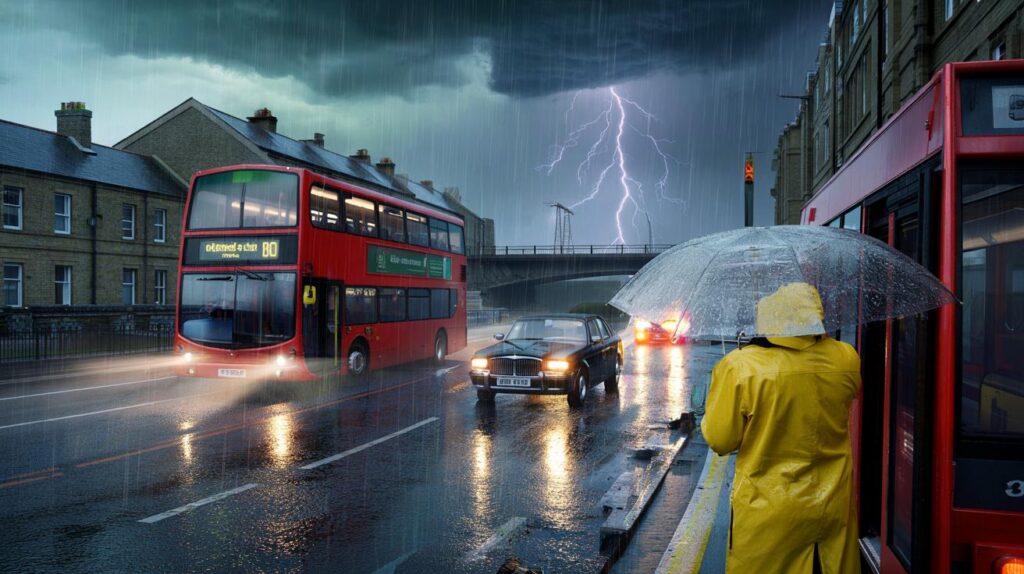
From breakfast to lunch, a turbulent strip of weather bears down on parts of south‑west England and south Wales, bringing a messy mix of rain, hail and lightning. The Met Office has issued a yellow thunderstorm warning, with the focus on a short but punchy window that could snarl roads and rattle power lines.
Yellow thunderstorm warning active from just after 8am to midday for parts of Gloucestershire, Wiltshire, Somerset and south Wales, with localised 30–40mm downpours, frequent lightning and hail.
Where and when the storms are expected
Forecasters expect a band of heavy showers and thunderstorms to push north through the warning area, affecting communities around Gloucester, Bath, Salisbury and Newport. The most intense activity sits within a four‑hour slot through late morning, with bursts of torrential rain and embedded thunderstorms.
Western districts start gusty and unsettled, with coastal gales reported early. Eastern counties may grab a brighter start with hazy sunshine, yet the wet weather line advances northwards and pivots inland by late morning, turning skies darker in a hurry.
| Area | Likely timing | Main hazards |
|---|---|---|
| Gloucester and surrounds | 08:00–12:00 | Intense rain, lightning, surface water |
| Bath and north Somerset | 08:00–12:00 | Hail, spray on roads, gusty winds |
| Salisbury and south Wiltshire | Late morning | Downpours, thunder, brief flooding |
| Newport and south Wales border | Morning | Lightning, standing water, poor visibility |
What a yellow warning means for you
A yellow warning signals a risk of weather causing disruption in places. Impacts will be hit‑and‑miss, but where storms form, conditions may deteriorate quickly.
- Difficult driving: sudden spray and standing water can hide potholes and reduce grip.
- Small chance of power cuts: lightning or falling branches may trip local lines.
- Local flooding: heavy bursts can overwhelm drains and flood low‑lying roads.
- Transport disruption: train and bus services may face delays or short‑notice changes.
- Structural damage: isolated hail and strong gusts could damage exposed roofs, greenhouses and scaffolding.
Thirty to forty millimetres of rain in a short spell can overwhelm drainage, cut visibility to a few car lengths and turn familiar routes treacherous.
Travel and safety advice
- Plan extra time and check for route updates before setting off.
- Slow down on wet roads and leave at least a five‑second gap to the vehicle ahead.
- Never drive through floodwater; even shallow flows can stall engines or lift a car off line.
- Secure loose items outside, including bins, garden furniture and ladders.
- Unplug sensitive electronics during intense lightning if safe to do so.
- Avoid sheltering under isolated trees during lightning; seek a substantial building or stay in your vehicle.
Rail, bus and road outlook
Short, intense downpours often trigger speed restrictions on railway lines and reduce headways on busy bus corridors. Expect spray on dual carriageways, short stretches of standing water on slip roads and occasional closures where drains back up. Check operator updates and consider earlier departures if you have time‑critical appointments.
What the meteorologists are seeing
Met Office guidance points to a volatile set‑up: a feed of humid air near the surface meets a passing trough, priming towering cloud tops and vigorous updrafts. That vertical motion supports hail formation and frequent lightning, while converging winds at low levels encourage storms to pulse along a narrow corridor rather than spread widely.
Meteorologists also noted a blustery start across western coasts, with gales clipping exposed headlands. Further east, early bright spells may lull some into a false sense of security before showers build and march north. The sharpest cells could drop hail and trigger brief squally gusts on their leading edges.
How to read the sky during a stormy morning
- Flat, grey rain with low cloud suggests prolonged heavy bursts and poor visibility on higher routes.
- Dark, towering clouds with crisp edges and a greenish tinge often hint at hail in the core.
- Frequent lightning indicates strong updrafts; storms can intensify rapidly where sunshine feeds warm surface air.
- “Flash‑to‑bang” guide: count seconds between lightning and thunder, then divide by three to estimate kilometres.
After the storms: a shot at a ‘blood moon’
Once the weather calms, attention turns upwards. A total lunar eclipse is due on Sunday evening, with the moon turning a deep red as Earth’s shadow passes across it. Where skies clear, the spectacle should be visible from around 7.30pm in parts of England and Wales. This is the first total lunar eclipse visible from the UK since 2022.
Will clouds spoil the view?
Residual cloud and shower bands may linger in western districts into the evening, while eastern areas stand a better chance of breaks. If the rain line edges away and winds nudge cloud south, a clear slot could open. A hilltop or open park with a low eastern horizon gives the best shot, and no equipment is needed.
What to watch over the next 24 hours
- Rapid surface‑water build‑up on urban streets where leaf fall starts to clog drains.
- Short, sharp hail bursts scuffing paintwork and greenhouse panels.
- Lightning strikes causing blips to local power and broadband networks.
- Small watercourses reacting quickly to intense showers, especially under slow‑moving cells.
- Gusty coastal winds easing later, but leaving choppy seas and tricky beach conditions.
Keep phones charged, move valuables off the floor in flood‑prone rooms, and report significant flooding via local authority channels.
Extra context to help you prepare
A yellow warning does not mean everyone will be hit; it signals that a few places could see impactful weather. Short bursts of 30–40mm in a couple of hours approach the threshold for local road flooding, especially near underpasses and dips. Garden projects and building works should pause during the warning, as hail and sudden gusts can turn loose materials hazardous.
Sports fixtures, markets and outdoor fairs sit at particular risk from lightning and slippery surfaces. Organisers should monitor radar, identify sturdy shelters and set clear pause‑play signals. Households near large trees may wish to park cars away from overhanging branches for the day. If your area misses the worst, treat it as a near‑miss drill: update emergency contacts, review insurance cover for storm damage and note safe alternative routes that avoid flood‑prone pinch points.


If the yellow warning hits Gloucester to Newport between 8 and 12, are train operators likely to impose speed restrictions? I’m a commmuter on the Bristol–Bath line and trying to decide whether to work from home. Also, is hail actually common in these set-ups or just “possible”?