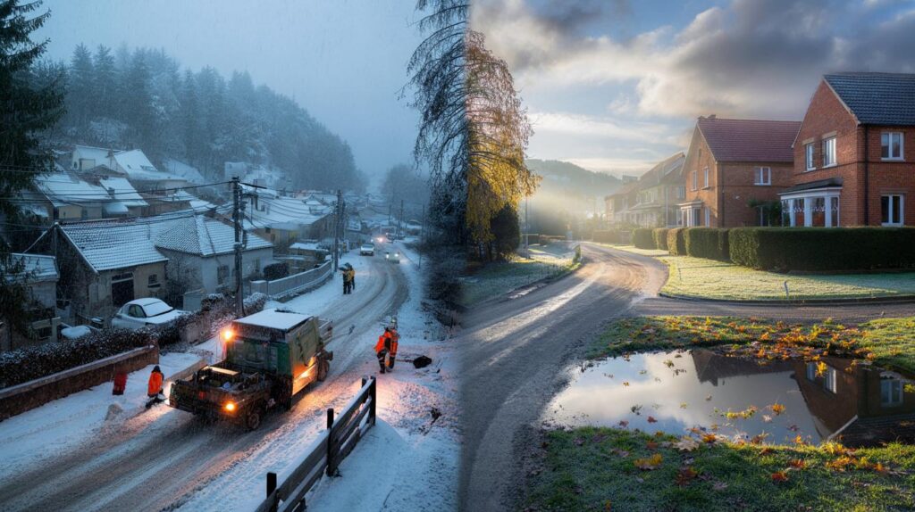
Across the continent, weather swung from late warmth to heavy flakes, jolting travellers and towns while stirring UK winter whispers.
As parts of Europe woke to half a metre of early snow, British eyes turned to the forecast. The Met Office has moved to steady expectations, pointing to a mainly dry, settled spell for much of October, even as photos of white hills and broken power lines spread from the Balkans.
Europe’s early snow shocks the Balkans
Higher slopes in Serbia and Bosnia picked up around 20 inches of snow in a matter of hours. Lower valleys faced cold rain, sodden ground and the risk of mudslides. Utility crews battled downed lines after trees snapped under the weight of wet snow. Some towns lost electricity as the band of wintry weather worked east to west along the Dinaric Alps.
The shift felt stark. Several Western Balkan cities touched 30C only days ago after a summer that repeatedly broke 40C. The sudden arrival of cold air collided with moist winds off the Adriatic. Orographic lift then squeezed moisture from the air mass, turning it to heavy, sticky snow above roughly 1,200 metres. Roads turned treacherous at altitude. Valley floors endured driving rain.
The Western Balkans saw around 20 inches of early-season snow at higher elevations, with power cuts and travel issues reported.
What the Met Office expects for October
In Britain, the signal is different. Meteorologists expect high pressure to take charge for much of the month’s middle third. That usually means light winds, benign days and chilly nights. The far north may grab passing fronts. Most places sit under quiet skies.
Week ahead: high pressure, calm days, chilly nights
From Friday 10 October to Sunday 19 October, forecast guidance points to a north–south split at times. The Northern Isles and fringes of northwest Scotland could catch patchy rain and brisk spells. Western coasts may see intermittent drizzle. For central and southern England, Wales and much of Northern Ireland, dry weather leads the way, with cloud breaks by day.
Radiation fog looks likely on several mornings. That fog should thin slowly after sunrise. Afternoon temperatures hover close to the seasonal norm. Under clear slots, nights turn cold enough for grass frost in rural dips.
For most of the UK, the signal is for dry, settled days and occasional fog, with isolated frost in the coldest rural spots.
Late October: a turn to wind and rain
During the final third of the month, pressure patterns start to shift. Confidence on the exact timing remains limited, but the Atlantic looks set to send more frequent systems our way. That raises the chance of widespread showers, longer spells of rain and brisk winds. Temperatures trend near average overall.
| Period | Weather signal | Temperatures | Wind | Confidence |
|---|---|---|---|---|
| 10–19 Oct | High pressure, mostly dry; fog risk | Near average by day; chilly nights | Light for most; breezier far north | Medium–high |
| 20–31 Oct | Turning more unsettled from the west | Near average | Increasingly blustery in places | Medium |
| Early Nov | Further showers or rain bands likely | Near average | Occasionally strong coastal gusts | Low–medium |
Why Europe snow does not mean UK snow
Two factors explain the contrast. First, the UK sits under an anticyclone for much of the next ten days. That blocks vigorous lows and keeps air stable. Stable air does not generate widespread snow. Second, the coldest pool currently favours eastern Europe and the Balkans. Britain’s airmass remains of Atlantic origin, not Arctic.
Topography also plays a part. Mountain chains in the Western Balkans amplify snowfall by forcing air uphill. The UK’s highest ground can grab early flakes when a cold outbreak aligns with moist flow, but the current set-up does not support that pathway.
There is no sign of UK snow in October’s forecast. A stronger chance of wind and rain emerges late in the month.
What this means for you
Expect a run of usable, if unremarkable, autumn days for much of England, Wales and Northern Ireland. Scotland sees the most changeable weather, especially in the northwest. Visibility may drop sharply at dawn where fog forms. Rural frost could nip tender plants.
Practical steps for the next 10 days
- Drivers: allow extra time on foggy mornings and keep de-icer handy for windscreens.
- Gardeners: protect late crops and containers from a touch of ground frost in frost hollows.
- Commuters: check early visibility reports; radiation fog can linger to mid-morning.
- Walkers: expect damp ground after overnight dew; choose routes with safe visibility in valleys.
- Home energy: test heating timers now before a cooler snap arrives late month.
How the setup evolves
High pressure tends to drift or weaken as the jet stream re-energises into late October. When that happens, fronts push in from the Atlantic. The detail matters: a quick succession of lows brings frequent, shorter bursts of rain and windy spells. A slower pattern brings longer, drizzly episodes with milder air. Either way, temperatures stay around par for the time of year.
For snow lovers, early-season prospects usually rely on a northerly or easterly outbreak, or elevation. None of those are on the cards for the next fortnight. Scottish summits could see sleet or wet snow briefly if a colder pocket clips the Highlands, but lowland snow signals remain absent.
Key dates and risks at a glance
- 10–13 Oct: widespread morning fog risk; pleasant afternoons where the sun breaks through.
- 14–16 Oct: cloudier interludes; western edges may see patchy drizzle.
- 17–19 Oct: still settled for most; coolest nights with isolated rural frost.
- 20–27 Oct: growing chance of frontal rain from the west; windier coasts and hills.
- 28–31 Oct: showers or longer rain spells likely; hill fog and gusts at times.
Why headlines jumped to snow talk
Pictures of deep October snow are rare, so the Balkan scenes travelled fast. Add a run of chilly nights in the UK and it is easy to assume flakes follow. Forecast models, though, point to a different UK story for now. The available moisture, the airmass source and the pressure pattern all limit the chance of snow at low levels.
If you crave a yardstick, model clusters and ensemble spreads show very low probabilities of UK snow in October at sea level. That probability rises into winter when the jet wobbles, blocking develops, or a sudden stratospheric warming shakes up the pattern. Those drivers are absent in the short term.
Extra context you can use
Fog forms when clear nights, light winds and damp ground allow air to cool to its dew point. That setup appears several times over the next week, especially in river valleys and basins. Plan journeys with reduced visibility in mind. In cities, urban heat can limit frost risk, but sheltered parks still dip close to freezing on the coldest nights.
For hill travel, carry winter layers even during settled spells. Calm weather hides rapid cooling after sunset. If unsettled conditions arrive late month, check mountain forecasts for wind chill and cloud base changes. Early sleet on Scottish tops is unlikely to persist, but slick paths and poor visibility can still catch walkers out.


Is 0% literally zero or just ‘near zero’? Ensembles can flip—what’s the confidence range and lead time behind that call?