An early blast of winter has stunned parts of Europe while Britain readies for a calmer spell and colder nights.
Rare October snowfall in the Western Balkans has sparked talk of an early British freeze, but official guidance paints a cooler, quieter picture. The Met Office says there is no sign of UK snow this month, though clear nights could bring pockets of frost and dense fog.
What the Met Office actually says
Social media buzzed with maps hinting at 20cm falling in northern Britain, yet the national forecaster has poured cold water on those claims. Guidance points to a spell dominated by high pressure, which favours settled, drier weather across most of the country before a shift to more changeable conditions later in October.
There is no indication of UK snow in October. High pressure leads first, then a turn towards wind and rain later in the month.
That means many areas will stay largely dry at first, with variable cloud by day and chilly, sometimes misty nights. The far north may grab occasional rain and brisk winds. As the month edges on, the pattern looks likely to loosen, allowing Atlantic systems to push showers and stronger gusts into most regions.
Why Europe turned white overnight
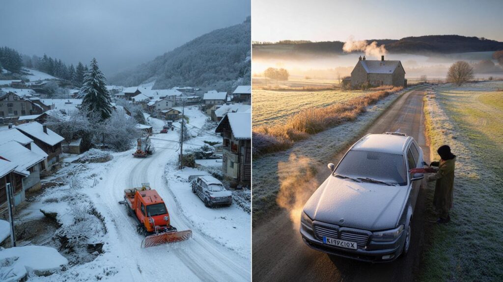
The Western Balkans jumped from late warmth to deep snow in hours. Hills and mountains in Serbia and Bosnia saw up to 20 inches (around half a metre), heavy enough to snap branches and pull down power lines. Lower valleys took a soaking, which raised concern for localised flooding and mudslides on saturated ground.
This switch came after a September that touched 30C in places, following summer spikes above 40C. A lurching jet stream allowed a cold pool to settle over the region while moist air climbed upslope into higher terrain. The result: early-season, water-laden snow that clings to trees and wires.
Up to 20 inches fell in the Western Balkans, with outages reported and travel severely disrupted on higher routes.
So, will you see snow in the UK this month?
In short, the signal says no. For widespread British snow in October, you would usually need a much colder air mass and the right setup for wintry showers. Forecast models do not currently show that combination. Instead, expect quiet days, chilly nights, and later a wobble back to wind and rain.
That said, late autumn often brings the first dustings over the highest Scottish summits as colder air brushes the Highlands, but the current guidance does not flag any imminent event. Urban lowlands stand an even slimmer chance while high pressure dominates.
Week-by-week outlook at a glance
| Period | Pattern | What you’ll notice |
|---|---|---|
| 10–19 October | High pressure in charge | Plenty of dry weather, light winds, patchy drizzle in the far north and west, fog at dawn, chilly nights |
| 20–31 October | Turning more unsettled | Rain and showers spreading to more areas, stronger winds at times, temperatures near average |
| Early November | Mixed start likely | Further spells of rain or showers with brief brighter breaks; any wintry risk confined to the highest Scottish peaks |
What this means for your plans
Settled spells can feel benign, but they bring their own hazards. Clear nights allow warmth to escape, cooling surfaces quickly. That sets up fog in river valleys and frost on exposed ground, especially in rural dips. Roads may stay damp under low cloud, keeping a slippery film where leaves collect.
- Morning commute: watch for dense fog pockets and slower travel on routes near rivers and fields.
- Gardens and allotments: protect tender plants; a light ground frost is possible in prone spots.
- Home energy: calm, cool nights can nudge heating use higher; check timers and bleed radiators.
- Outdoor events: plan for grey starts, brighter breaks later, and a quick chill after sunset.
The science behind the split picture
How can the Balkans be knee-deep in snow while Britain stays mostly dry? It often comes down to where the jet stream meanders. A southward dip over south-eastern Europe allowed cold air to pool there. Farther northwest, the UK sits under a ridge of high pressure, which stabilises the air and shuts down widespread rainfall and snow production.
When that ridge weakens later in the month, Atlantic low-pressure systems can return. These bring the familiar British mix of bands of rain, gusty intervals, and cooler clear slots between fronts. In such a regime, snow requires an injection of markedly cold air and the right precipitation timing — more common from late November onwards.
Key takeaways for the next three weeks
No October snow signal for the UK. Expect fog and occasional frost under high pressure, then a wind-and-rain reset later.
Temperatures should sit close to the seasonal norm overall. Days may feel mild where sunshine breaks through, but evenings quickly cool under clear skies. Overnight values can dip to low single figures in rural areas, with isolated pockets near freezing on the coldest nights.
Practical prep if you’re hoping — or dreading — the first flakes
Even without imminent snow, early preparation pays dividends. Check the basics now to dodge a rush when the first wintry chart appears.
- Tyres and wipers: inspect tread and replace streaking blades; top up screenwash rated for colder temperatures.
- Footpaths: clear leaves before they compact and turn slick; treat with grit if you live in a frost hollow.
- Boilers and vents: book a service and clear external flues; calm, foggy nights can highlight weak ventilation.
- Power resilience: keep a small torch and batteries handy; wet foliage and breezy spells can still drop branches onto lines.
Looking beyond October
Long-range outlooks carry uncertainty, yet some cues help. If the Atlantic remains active into November, rain and wind will dominate. For lowland snow chances to rise, Britain often needs a northerly or easterly feed delivering colder continental or polar air. That requires a more profound shift in pressure patterns than models are signalling right now.
For mountain enthusiasts, the first proper Scottish snows often build in November. Resorts watch freezing levels, humidity, and wind direction as much as temperature. A brief northerly burst can lay a base above 900–1,000 metres, but lasting cover needs repeated cold shots and minimal thaw between them.


So no snow, just frost? Back to scraping windscreens then.
The Met Office says “no flakes”, but they’ve been wrong before—are you 100% sure a late northerly burst won’t sneek in? Feels a bit optimistic tbh.