A burst of polar air threatens to flip the season this weekend, nudging thermometers down and putting travel plans in doubt.
Computer models have turned colder for the second half of the weekend, pointing to a short, sharp chill. Central Scotland sits in the firing line for the first flakes of the autumn, while parts of northern England brace for heavy rain and gusty spells.
Where and when the first flakes could fall
By the early hours of Sunday, central Scotland may see wintry showers on higher ground as air temperatures slide towards 0C. Forecasters using WX Charts, based on MetDesk data, flag enough cold air aloft to turn rain to sleet or wet snow for a time, especially over hills.
This is a marginal setup. Ground temperatures in towns will sit above freezing. Any settling would favour upland routes and exposed passes where wind chill bites hardest.
Early Sunday is the key window: brief sleet or wet snow is possible over Scottish hills as temperatures flirt with 0C.
The four counties in the frame
Central Scotland’s traditional counties most at risk include:
- Stirlingshire – showers pivoting off the Highlands could turn wintry over the Campsies and higher slopes.
- Clackmannanshire – brief sleet possible near the Ochils during the coldest hours before dawn.
- West Lothian – a low chance of wintry mix on the highest spots, mainly short-lived.
- Perthshire (southern parts) – showers feeding south may turn wintry above the glens and exposed hilltops.
Lower ground from Falkirk to Livingston should see rain and blustery showers. Any snow would be fleeting and elevation-dependent.
| County | Likely window | Elevation most at risk | Overnight low | Confidence |
|---|---|---|---|---|
| Stirlingshire | Late Sat to Sun dawn | Above 300–400m | 0–2C | Moderate |
| Clackmannanshire | Sun pre-dawn | Above 300–400m | 0–2C | Moderate |
| West Lothian | Sun pre-dawn | Above 250–350m | 1–3C | Low to moderate |
| Perthshire (south) | Late Sat to Sun dawn | Above 350–500m | 0–2C | Moderate |
Rain, wind and a north–south split
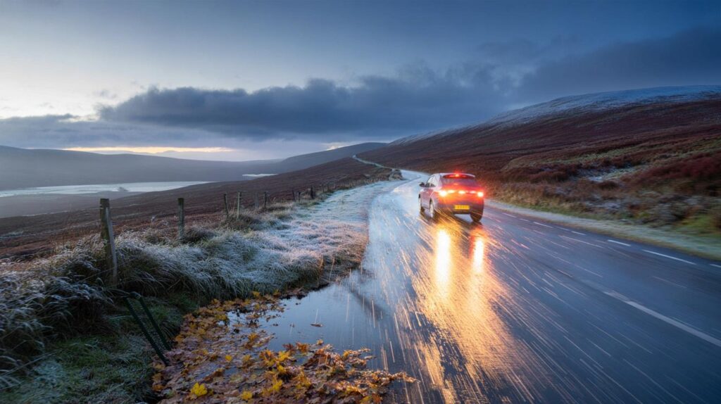
While Scotland feels the chill, northern England looks wet. Bands of rain sweep east on Saturday into Sunday, turning heavy in places. Stronger gusts clip exposed coasts and hills. Puddling, leaf-clogged drains and spray are likely on main routes across Cumbria, Northumberland and the Pennines.
Forecast guidance from the Met Office signals an unsettled start with widespread showers for central, southern and eastern areas. A classic northwest–southeast split then develops. The north and northwest gain the best chance of longer dry spells between fronts, while low pressure keeps showers going further south and east.
Northerly winds will feed colder air for a time, bringing rural frost risk and patchy fog where skies clear overnight.
What the models say about next week
Into next week, winds trend northerly before easing as pressure rises from the west. That pattern nudges daytime temperatures down towards seasonal norms. Nights turn crisp, especially in rural glens and sheltered valleys. Later, high pressure may steady things with brighter intervals, but coastal showers could linger on windward shores.
Longer range signals into early October carry low confidence. Slow-moving patterns look plausible, with high pressure close to the UK at times. That would bring windows of dry weather, punctuated by nearby lows that can shuffle rain back across the country. Temperatures bob either side of average.
How likely is snow at your postcode?
Think in layers: air temperature, ground warmth, elevation and precipitation type. You need all of them aligned for settling snow in September, which is uncommon at low levels. This weekend’s setup finds the coldest air brushing Scotland first, then moderating quickly.
- If you live above 300 metres, a pre-dawn wintry mix is plausible for a short spell.
- Below 200 metres, odds strongly favour cold rain and hail-like showers rather than settling snow.
- Urban surfaces stay too warm for laying; grassy banks and car roofs cool faster.
- Road ice is unlikely but sharp wind chill can make conditions feel sub-zero.
Travel and safety: practical steps for the weekend
Drivers crossing upland routes such as the A9 and A82 should plan for squally showers, sudden visibility drops and gusts. Check tyre tread and washer fluid before night journeys. Cyclists and walkers on exposed ridges need extra layers, a waterproof shell and spare gloves. Rail users may see minor timetable changes if leaf-fall and standing water slow lines.
Homeowners can use the first cold snap as a systems check. Test the boiler timer, bleed radiators, and locate the stopcock ahead of deeper winter. Secure garden furniture and trampolines before gusts arrive. Pet owners should shorten late-night walks if wind-driven rain intensifies.
What to watch on your weather app
Key signals to track on Saturday evening include wind direction backing to the north or northeast, a dip in wet-bulb temperature near 0–1C on hill stations, and a shift from rain to mixed-phase precipitation on radar. Bright blue echoes speckled with pink often flag sleet and wet snow in radar palettes.
Short, sharp cold snaps arrive fast and leave fast. The window for wintry showers is measured in hours, not days.
Why early-season snow can happen
September snow in Scotland relies on cold upper air riding south behind an active front. If showers align in a northerly, they stream directly into the Central Belt’s hills. The sun angle still adds daytime warmth, so nocturnal timing matters. Clear breaks let heat escape, nudging temperatures down just enough for a transient wintry mix on peaks and passes.
For hill users, wind chill matters as much as the thermometer. A 25–35 mph gust lowers apparent temperature by several degrees. Wet kit and exposed skin increase heat loss. Plan shorter routes, set cut-off times, and carry a headtorch as daylight shortens.
The bottom line for the weekend
Expect a colder feel nationwide, with Scotland turning wintry over higher ground for a brief window late Saturday into Sunday. Northern England takes the brunt of the rain. The broader pattern then favours a changeable week, a few brighter pauses in the northwest, and a cool, crisp start to October if high pressure noses in.
If you need a rough rule: hills may see sleet or wet snow before breakfast on Sunday; cities get chilly rain and blustery showers. Keep an eye on the latest local updates on Saturday evening, and adjust plans if bands of heavier precipitation stall over your area.


So, will Livingston actually wake to 0C on Sunday, or is it definately just cold rain? Trying to plan a run.
Appreciate the heads-up on Stirlingshire and the A82 — the travel tips are gold. I’ll top up washer fluid and pack spare gloves tonight.