A sharp northerly plunge is about to jolt the UK after a mild spell, flipping umbrellas and nipping noses.
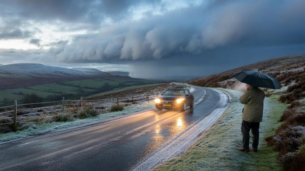
By Sunday, forecasters expect central Scotland to flirt with the first flakes of the season, while northern England soaks under bands of rain. Temperatures could dip to 0C before dawn, sharpening the risk of rural frost and slick roads.
Where the first flakes are most likely
Early model guidance points to central Scotland as the most likely area to catch the UK’s first autumn snow. A pocket of cold air drops south this weekend. That brings sub-zero feels-like temperatures on high ground and a marginal snow set-up at lower elevations.
Model charts based on MetDesk data flag a brief 0C window before sunrise on Sunday across parts of central Scotland, raising the prospect of early-season flakes.
Forecasters say the risk sits over the Central Belt and the uplands around it. Wet snow or sleety showers are favoured at first. Any settling is most likely over higher routes and hills where the air is colder.
The four counties in the frame
- Stirlingshire: showers turning wintry over the Campsies and the Trossachs, mainly on peaks and passes.
- Clackmannanshire: the Ochils most exposed to sleety bursts, with wet roads in valleys.
- West Lothian: a low chance of flakes mixed into rain overnight, especially towards higher spots.
- Perthshire (southern parts): upland fringes best placed for a brief dusting if showers align.
Lower towns and cities in these counties are likely to see cold rain or sleet. Any early flakes may melt on contact with warmer surfaces. Road temperatures can lag behind air temperatures, so bridges and rural bends could still turn slippery.
Rain for millions across the north
While Scotland dodges between sleet and snow, northern England looks set for a thorough soaking. Bands of rain will move south through the weekend, fed by a chilly northerly flow. The heaviest falls favour the Pennines and Cumbrian fells.
Northern England faces a spell of persistent, occasionally heavy rain on Sunday, with gusty winds along exposed coasts and hills.
Urban run-off may pond on known trouble spots. Commuters should allow extra time. Fallen leaves can block drains and make pavements slick. Coastal strips from Northumberland to Lancashire could feel brisk winds. Temperatures stay on the cool side for mid-September, amplifying the raw feel.
What official forecasts say about the pattern
The Met Office signals an unsettled start, with rain and showers most widespread across central, southern and eastern parts for a time. Stronger winds may accompany the downpours near frontal zones. Into next week, a northwest–southeast split becomes more likely. Southern and eastern areas keep the showers near a nearby area of low pressure. The north and northwest hold the better chance of longer, drier spells. Patchy fog could form overnight where skies clear. Rural frost is possible where winds fall light.
A colder feel takes hold as a northerly flow sets in for a time, before high pressure brings a calmer interlude for some.
Later in the period, higher pressure may exert more influence and bring more settled weather. A few coastal showers may linger in onshore winds. Temperatures should tend to edge back towards seasonal norms after the initial cool burst. Broadcasters also flag a cooler trend through late September, with changeable pulses never far away.
When and where: the weekend at a glance
| Time | Area | What to expect |
|---|---|---|
| Saturday night | Central Scotland | Showers turning sleety on hills; brief 0C pockets before dawn. |
| Sunday morning | Stirlingshire, Clackmannanshire, West Lothian, parts of Perthshire | Wintry mix possible; mostly wet at low levels; icy patches on rural routes. |
| Sunday daytime | Northern England | Persistent rain, heavy at times; gusty on coasts and over high ground. |
| Sunday night | Northwest and Highlands | Clearer slots possible; risk of fog and a touch of ground frost inland. |
Travel, health and home: steps to take before Sunday
Driving and commuting
- Plan routes that avoid high passes if wintry showers arrive, especially at dawn.
- Check tyre tread and washer fluid. Carry a scraper for early frost on screens.
- Slow on leaf-covered roads and bridge decks, which cool and ice faster.
At home
- Clear gutters and drain grates to reduce ponding during heavy bursts of rain.
- Test heating before the first cold snap, and bleed radiators if needed.
- Secure loose garden items ahead of gusty coastal spells.
Why a northerly can bring early flakes
Air arriving from the north often travels over cool seas and picks up moisture. When that air crosses uplands in Scotland, it rises, cools and condenses. That process can flip showers to sleet or snow even in September, especially above a few hundred metres. Lower down, the ground retains summer warmth, so most flakes melt. Brief bursts of heavier precipitation can overcome that warmth for a time, which is why hill routes see the earliest hints of winter.
What to watch beyond September
Confidence is low for early October, but the broad signal points to slow-moving patterns. High pressure may sit close to the UK at times. That brings calmer days with chilly nights and fog risk. Nearby lows could still swing rain bands across parts of the country between settled spells. Temperatures are likely to wobble around the seasonal average.
Extra context to help you plan
Snow, sleet and hail behave differently on the road. Sleet often looks like heavy rain but reduces grip quickly. Hail forms sudden white-outs in showers and can stack up on shaded lanes. If you live near the Ochils or the Campsies, assume temperatures can run 2–3C lower than nearby lowland forecasts during night-time bursts. That difference matters for ice risk.
For outdoor events this weekend, favour flexible plans. Consider earlier start times on Sunday to dodge the wettest bands in northern England. Walkers in the southern Highlands should pack a warm layer and a waterproof shell. Short, sharp showers can drop the temperature fast on ridges. Cyclists should pick routes with lower exposure and prepare for side winds on open moorland.


Anyone know if councils plan to grit the higher routes in West Lothian before dawn Sunday? The article mentions icy patches on rural bends—curious about bridge decks near the Bathgate Hills. Commuters here got caugh out last year when road temps lagged air temps.
Umbrella-flipping northerly is back—time to deploy the inside-out brolly and the emergency scraper 🙂 If the Ochils run 2–3C lower, I’m upgrading my Sunday dog walk to crampon-lite. Anyone else pre-heating radiators tonight or just layering like an onion?