A colder pattern is edging in as nights lengthen, with a tug-of-war between crisp air and stubborn bands of rain.
Forecasters now flag a meaningful chance of up to 10cm of snow on Scottish high ground around 21 October, while rain belts soak millions further south. Temperatures are forecast to dip close to freezing over the Highlands, with sleet or wet snow briefly pushing towards lower levels as the day wears on.
Where and when the snow is most likely
Computer models indicate a wintry window over northern Scotland in the third week of October. The Cairngorms and surrounding Highlands sit in the firing line, with a short, sharp burst of snowfall most plausible between about 6am and noon on 21 October if current projections verify. Accumulations look most credible above 300–400 metres, where ground cooling will be sufficient to hold a covering.
Up to 10cm could settle on higher routes in the Highlands on 21 October, with temperatures near 0–2C at daybreak.
Edinburgh lies on the southern edge of the colder air. Any flakes there would be fleeting and most likely arrive as a mix of rain, sleet and small hail during showers. Further west and south, the snow line rises quickly; central belt towns can expect cold rain rather than a postcard scene.
Signals also point to a low-probability chance of flakes over the highest peaks in North Wales late in the month if the colder pool dips further south overnight. That would be confined to the very tops of Snowdonia, with no significant settling expected on valleys.
What the models are showing
WXCharts output, driven by MetDesk data, shifts the UK into a colder north to north-easterly feed for a time in the mid-to-late month period. The GFS global model has repeatedly hinted at an early-season snowfall over Scottish mountains, raising the prospect of a “white October” cameo well before winter proper begins.
High pressure building towards the Norwegian Sea could spin a north-easterly flow, nudging colder air across Scotland and cloudier, cooler conditions into eastern England.
This pattern matters. A high near the Norwegian Sea blocks Atlantic systems and deflects winds clockwise, drawing in cooler, drier air for many. Where that flow rides up over mountains, moisture wrung from the air can turn to snow if the freezing level drops below summit height. Small shifts in wind direction, moisture and temperature—just a degree or two—will decide whether the Highlands see slush or a crisp 5–10cm cover.
Rain for millions further south
Northern England looks set for a soaking as frontal systems queue up on the southern flank of the colder air. A long, persistent rain band could stretch across hundreds of miles, periodically intensifying and reducing visibility on key routes. Localised surface-water flooding is possible where drains clog with early leaf fall.
- North West and Yorkshire: periods of heavy rain, poor visibility on higher stretches of the M62 and A66.
- North East: brisk onshore winds, prolonged outbreaks of rain, and a raw feel near the coast.
- Midlands fringe: lighter pulses of rain, turning drizzly with low cloud and hill fog.
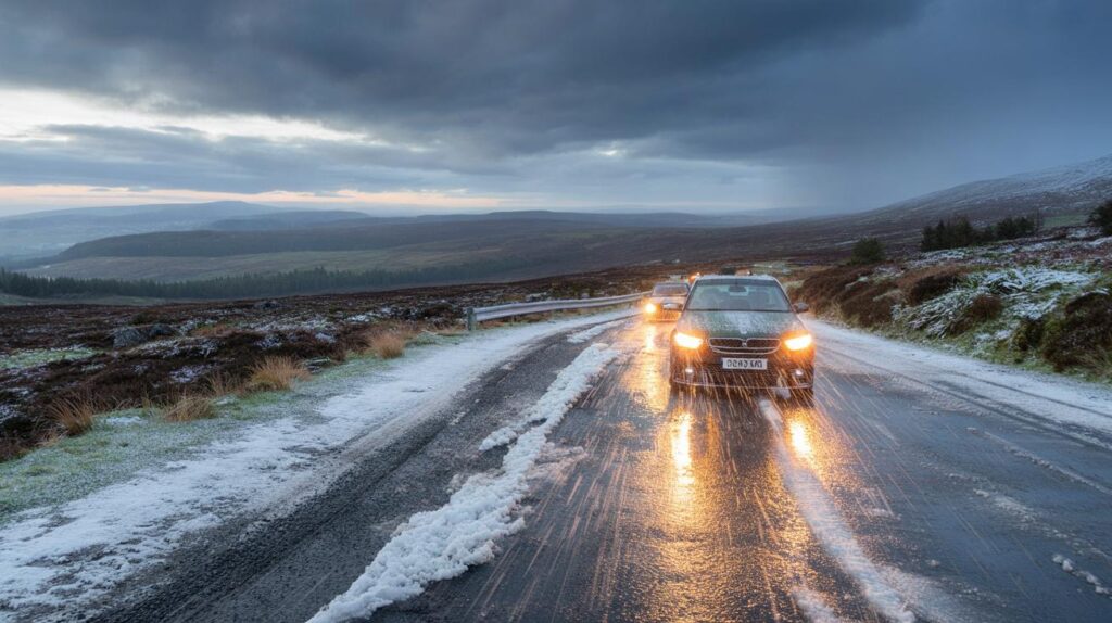
Travel, power and daily life: what to expect
Short-lived, early-season snow can still cause outsized disruption. Higher passes through the Highlands, including routes near the Cairngorms, may see slushy accumulations and sudden drops in grip. Morning commuters should allow extra time, as road temperatures can briefly slip below air temperatures at dawn, icing untreated stretches and bridge decks. Blustery showers could also bring hail, which reduces tyre contact as effectively as compact snow.
| Date | Region | Likely conditions | Temperatures |
|---|---|---|---|
| 21 Oct, morning | Scottish Highlands | Snow 5–10cm above 300–400m, slushy below | 0–3C |
| 21 Oct, afternoon | Central belt incl. Edinburgh | Cold rain with sleet or small hail in showers | 1–4C |
| Late Oct, nights | North Wales high tops | Isolated flurries on peaks, little settling | 1–3C on summits |
| Mid–late Oct | Northern England | Persistent heavy rain, localised surface flooding | 3–8C |
| Next week | Eastern England | Cloudy with a few coastal showers in a NE flow | 7–11C |
Power flickers are most likely where wet snow clings to upland lines and gusts shake branches. Urban areas south of the Central Belt face a different set of issues: spray and standing water, longer braking distances, and low cloud tangling with hills to create fog pockets. Airlines rarely face major disruption from these brief October episodes, though early departures may need de-icing in the north if skies clear overnight.
What high pressure means for the rest of us
For England and much of Wales, a nearby high should keep things largely settled for a spell. Days feel cool but quiet. Nights turn noticeably colder under clear skies, with rural frost a decent bet where winds drop. A north-easterly drift into eastern counties brings thicker cloud and the odd coastal shower, but many inland spots remain dry. Gardeners should protect tender plants; first frosts can arrive earlier than memory suggests when winds swing north of east.
Key signals to track before the weekend
Keep an eye on the freezing level over Scotland—it needs to dip below 700–800 metres for settling snow to push beyond the highest ridges. Watch wind direction in the North Sea; a few degrees of veer towards due north can sharpen the cold. Finally, track dew points at dawn. When dew point hugs 0C, wet snow is more likely to stick briefly on cold surfaces.
The overlap of a cold morning, a saturated air mass and upland terrain is the recipe for those first autumn flakes.
For hillwalkers and ski-centre teams, early snowfall offers a valuable test of drainage, fencing and piste machinery after summer maintenance. It rarely lasts long, but it can build a compacted base on the shadiest slopes if a second burst arrives within days. Drivers crossing the A9 and other exposed routes should carry warm layers, a torch and a scraper; a five-minute flurry is enough to glaze windscreens and hide black ice in lay-bys.
Beyond the initial burst, the broader pattern hints at a stop–start start to late October: chilly mornings, occasional fog, and onshore breezes for the east. If high pressure persists near the Norwegian Sea, eastern counties will feel cooler than the thermometer suggests, while western hills squeeze out further pulses of rain. A small southward nudge of the cold pool could expand the risk of hill snow in Wales and northern England, but for now, the strongest signal remains over the Scottish Highlands.


Four inches already? Somewhere in Britain a BBQ is being wheeled back into the shed. Feels early for a “white October” cameo!
Helpful heads-up. If the freezing level dips below 700–800m, A9 and Cairngorm routes could glaze fast—carry warm layers, a torch, and a scraper.