The Met Office has issued a fresh three‑month winter outlook, flagging a season that may swing between icy snaps and stormy bursts. It’s not doomscroll fuel, but it is a nudge: the next quarter could be disruptive in very British ways.
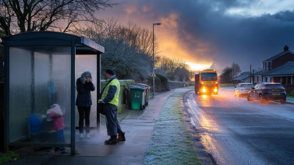
The alert pinged my phone just after dawn, that thin blue hour when the bus shelter glass fogs with breath and the pavement still holds last night’s shine. A man in a high‑vis jacket was tapping his boots on the curb, watching the sky like it owed him an answer. On the bench, a mum zipped a scarf over a toddler’s mouth and whispered that she couldn’t face another week of train delays. We’ve all had that moment when winter feels bigger than your plans.
Out by the allotments, puddles were already crisping at the edges. The air had that metallic smell, part grit, part cold iron. The Met Office’s three‑month outlook doesn’t shout, it hints. This time, the horizon looks twitchy.
What the three‑month winter outlook is really saying
The Met Office’s seasonal outlook is not a crystal ball. It’s a signal about likelihoods: a tilt towards **Arctic snaps**, a nudge towards wetter‑than‑average spells in the west, a raised eyebrow at windier interludes. The picture this winter points to a stop‑start pattern, the kind that catches you out on bin day. Expect days that feel unremarkable, then a quick plunge into ice and sleet that tangles the commute.
Think back to that week when your street went from drizzle to glass overnight. The gritters moved late, buses crawled, and by lunch a sharp sun made it all look harmless again. In a village outside Durham, I watched a corner shop sell out of batteries before the lunchtime rush as gusts rattled the tilting sign. The weather didn’t break anything dramatic. It simply layered small hassles until everything felt uphill.
Here’s the logic behind the hints. A lively North Atlantic means the jet stream could wobble south, steering frequent low‑pressure systems towards the UK and creating alternating pulses: wind‑rain bursts, then northerly draws of cold that sharpen into frost and the odd hill snow. If the stratosphere misbehaves and a sudden warming event unfolds, the odds of a lock‑in cold spell jump. No guarantees, just a weather deck stacked toward **storm‑track risk** and intermittent chills.
Practical moves before temperatures dive
Start with warmth you can feel in minutes. Bleed radiators until the top panel heats evenly, set your boiler to a steady, modest flow temperature, and tuck a cheap draught excluder along that shimmying back door. Wrap any exposed pipes with foam sleeves and know where your stopcock is, so a burst doesn’t become a flood. A rubber squeegee by the front mat will be your best friend on slushy days.
There’s a rhythm to winter prep that often slips by. People wait for the first icy morning to buy grit, then find the aisle bare and settle for cat litter. Let’s be honest: no one actually does that every day. Stash a small “cold kit” now: torch, spare phone battery, gloves, basic meds, a hat you won’t mind losing. If you drive, keep a blanket and a compact shovel in the boot. That way a stuck gate, a dead light, or a surprise wait on a platform is a nuisance, not a saga.
One thing the Met Office repeats, quietly but firmly: rain on rain is what tips rivers.
“Long‑range outlooks are probabilities, not promises. Prepare for the plausible, not the perfect forecast,”
says one veteran forecaster.
- Watch local river updates when systems line up.
- Move valuables off the floor in flood‑prone rooms.
- Photograph your home now for insurance baselines.
- Keep gutters clear before the next wind‑driven rain.
*Small, boring chores make big, boring problems less likely.*
Why this matters beyond the weather
Winter is never just a temperature map. It’s train timetables, school runs, energy bills, and whether the high street stays open late on a Thursday. The Met Office’s three‑month warning speaks to that whole web. A choppy season means more staff calling in late, deliveries slipping, and a higher chance of power flickers when wind meets trees that still hold a few leaves. For many, the question isn’t “Will it snow?” It’s “Will the day still add up?”
Energy is the thread running through every conversation. A few degrees one way or the other shifts how often the boiler fires and how long you hover by the thermostat after 8pm. **Energy bills** don’t care how romantic frost looks under a lamppost. If the outlook leans cooler at times, think behaviours, not just tariffs: heat the person, not the whole room; close the spare room door; batch‑cook when the oven’s already on; and pull curtains before dark. It’s not glamorous. It works.
Community matters too. On my street, we keep a group chat alive when weather turns: who’s out with the dog, who can pick up milk, whose internet just dropped. The outlook won’t tell you when Mrs Patel’s boiler will sulk, or if the 7:42 will mislay its driver. It does say the season might throw more of those little tests at us. That’s not a forecast to fear. It’s a cue to knit the net a bit tighter.
What’s coming, in human terms
The signal is for a mixed winter that occasionally bites. Expect spells of heavy rain tracking in from the Atlantic, gusts that topple bins and flex fences, and snap frosts that polish pavements into slip lanes by breakfast. Snow? Most likely on high ground and in northerly flows, with fleeting low‑level slush when the air lines up just right. Travel will wobble at times. So will patience.
There’s a brightness to winter days that go right. A low sun, a clean wind, a town that hums. There’s also the winter that gets into your admin: a failed meeting because of frozen points, a parcel looped back by road closures, a kid’s match called off at the last minute. That’s what the Met Office warning is really about. Not drama for drama’s sake. The friction of small things when the weather is in a mood.
So share the ride. Text a neighbour if you’re already at the shop. Lay out tomorrow’s warm kit by the front door. Take five minutes to read the local forecast, not just the headline. The big patterns will come and go. What sticks is how we move around them, together.
| Key points | Details | Interest for reader |
|---|---|---|
| Three‑month signal | Higher chance of alternating stormy bursts and cold snaps | Plan travel and routines around likely disruptors |
| Flood and wind risk | Successive rain systems, gusty spells as jet stream dips | Protect property, follow local alerts, avoid last‑minute scrambles |
| Everyday prep | Bleed radiators, insulate pipes, stock a small “cold kit” | Lower stress, reduce costs, stay flexible on tough days |
FAQ :
- Is this a guarantee of severe weather?The Met Office outlook gives probabilities, not certainties. It signals risks so you can prepare without panic.
- Will it snow where I live?Lower levels may see brief slushy episodes; lasting snow is more likely on high ground or during northerly flows.
- Should I change my energy plan now?Consider usage first. Small efficiency wins often deliver quicker savings than switching in a rush.
- What’s the best time to travel?Early afternoons often dodge frost and peak wind. Check same‑day forecasts and live updates before leaving.
- How do I follow the latest alerts?Use the Met Office app, enable region‑specific notifications, and keep an eye on local authority feeds.


Really clear rundown—thanks. Not alarmist, just useful. The everyday prep tips (bleed rads, insulate pipes) are exactly what most of us forget.
So… a 3‑month “signal” that could be cold, wet, windy—or not? That’s some premium hedging. I respect the Met Office, but this reads like a weather horoscope tbh. Prove me wrong, plz; I’m definitly listening.