Winter scenes across the Balkans have stirred British curiosity, with many wondering what the next fortnight holds at home.
Forecasters see a quieter picture for the UK, even as Europe grapples with early snow. Signals point to high pressure first, then a shift to wind and rain later.
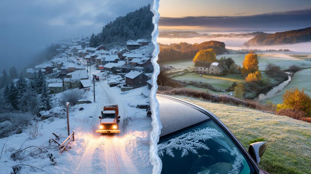
What happened in europe
An abrupt cold turn swept the western Balkans, where upland districts in Serbia and Bosnia woke to deep snow and widespread disruption. Crews battled power cuts as heavy, wet snow and broken branches brought down lines. Lower valleys faced persistent rain, inflating the risk of floods and mudslides.
At higher elevations, totals climbed beyond 20 inches, an unusual haul for early October. Meteorologists in the region warned that some mountain gauges could edge towards October records if showers persisted. The abrupt switch followed a September that still touched 30C in places, after a summer that repeatedly topped 40C.
Up to 20 inches fell in parts of the western Balkans, knocking out power and closing routes, just weeks after 30C heat.
| Area | Recent conditions | Typical temperature range |
|---|---|---|
| Serbia (hills) | Heavy, wet snow; line damage; travel disruption | -2C to 5C |
| Bosnia (uplands) | Persistent snow; drifting on exposed routes | -3C to 4C |
| Balkan lowlands | Cold rain; local flood and mudslide concerns | 3C to 9C |
| UK (most areas) | Dry spells under high pressure; chilly nights | 6C to 15C |
What the met office says for the uk
Despite the European whiteout, the Met Office guidance for October signals a different story for Britain. Forecasters see no indication of snow in the UK through October, with a largely dry, settled spell developing for many in the near term.
No indication of UK snow in October: expect dry, settled spells first, then a turn to wet and windy later.
Next 10 days: dry days, chilly nights
From Friday 10 October into the following weekend, high pressure looks set to anchor near or over the UK. That pattern usually means light winds, large day-to-day contrasts, and limited rainfall outside the far north and west.
- Far north: patchy rain or drizzle at times, breezy on exposed coasts and hills.
- West: odd shower or drizzle in Atlantic-facing areas; many places dry.
- Elsewhere: brighter spells by day, variable cloud, and light winds.
- Nights: mist and fog in prone spots; slow to clear in the morning.
- Temperatures: near average overall; rural dips could bring isolated grass frost.
In practical terms, gardeners should be ready to protect tender plants on the clearest nights. Commuters may encounter patches of fog on early runs, especially in river valleys and around known fog hotspots.
Late october: a change brewing
Through the final third of the month, high pressure is expected to give way. Two broad scenarios exist: a train of Atlantic lows or a slower-evolving pattern that still brings more frequent rain bands. Either way, the balance tilts towards wet spells, showers and fresher winds, at times strong near coasts and over higher ground. Temperatures stay broadly near seasonal norms into early November.
Why european snow does not guarantee british snow
Early snow on the continent often comes from a cold pool dropping south over the Balkans while the Atlantic remains comparatively mild. The UK sits between the two, and the position of the jet stream decides who gets what. With high pressure nearby, Britain tends to see settled weather, not wintry outbreaks.
Sea temperatures around our shores, still relatively warm after summer, add another buffer. Air crossing those waters picks up heat and moisture, raising snow thresholds. In October, low-level UK snow usually needs a potent Arctic plunge, upslope lift, and night-time cooling. That package appears absent in the current outlook.
Where snow is still possible in october
While a widespread fall is unlikely, fringes of the Scottish Highlands can see flakes any month, given altitude and exposure. Brief sleety mixes over the highest Munros are not unheard of in late October when a northerly snaps through. The present guidance leans away from that in the medium range, but a very short, showery northerly late in the month cannot be ruled out. Any such event would be brief and localised.
Signals to watch
- High pressure position: a shift west can open a northerly corridor; a shift east keeps it calmer but cloudier.
- Jet stream latitude: a southward dip drags fronts across the UK; a flatter track spares the south and east.
- Overnight inversions: calm, clear nights mean fog and frost risk without daytime snowfall.
What this means for you this week
Households can expect lower rainfall totals than average in many regions at first. Heating use may rise overnight where skies clear, then ease under sunny spells by day. Outdoor plans look feasible for much of England and Wales, with Scotland and Northern Ireland seeing more cloud and occasional drizzle in the north and west.
Travel impacts are more likely from fog than from wintry roads. Allow extra time for de-icing in rural frost hollows. Keep an eye on visibility warnings in the morning commute window, typically 5am to 9am.
Extra context for the weather-curious
High pressure acts like a lid. It suppresses uplift, weakening clouds and showers. With light winds, air near the surface cools quickly at night, forming fog. By late morning, sunshine or a slight breeze mixes that cool layer away, leaving a brighter afternoon. That cycle breaks once Atlantic systems return, lifting the lid with fronts and stronger winds.
Snow potential rises markedly in November as seas cool and polar air masses deepen. Early-season events tend to favour hills in Scotland and northern England during short northerly or north-westerly shots. Lowland, widespread UK snow usually waits for deeper winter when ground temperatures and daylight length work in tandem with cold air aloft.
Practical checklist for the next 14 days
- Gardens: prepare fleece or cloches for tender plants; clear leaves from drains before wetter spells arrive.
- Home: test heating timers; bleed radiators to improve efficiency during chilly nights.
- Travel: pack an ice scraper and microfibre cloth; plan for local fog on early starts.
- Health: those with respiratory issues may feel foggy, damp mornings more keenly; keep inhalers accessible.
Bottom line for October: dry and settled to start, a wetter and windier turn later, temperatures near average, and no firm signal for UK snow.


Europe’s buried under 20 inches and we get fog and drizzle—are the modles underplaying a northerly snap again, or is the warm sea still a deal-breaker?