Grey skies are rolling in from the Atlantic while trains, roads and routines could feel the strain before lunchtime.
A 14-hour spell of rain is bearing down on parts of England and Wales, with the Met Office urging people in 31 local authority areas to prepare for possible disruption. The guidance includes packing a simple emergency kit and planning journeys as spray, standing water and short-notice changes to public transport become more likely.
Rain pushes in overnight, with a messy Wednesday morning ahead
The Met Office has issued a yellow warning for heavy rain from midnight to 2pm on Wednesday, covering large parts of the South West and south Wales, with adjacent counties in the South East also highlighted. Bands of rain will pivot across the warning area, with some locations seeing several hours of persistent downpours and others catching intense bursts.
Expect a 14-hour window, from 00:00 to 14:00, where rain, surface water and slower journeys become more likely.
Forecasters warn that roads could turn slick quickly, visibility will drop under heavier pulses, and some rail and bus services may run late or be cancelled. A small number of homes and businesses could see water entering ground floors, and brief interruptions to power and other services cannot be ruled out where the heaviest rain sets up.
Third‑party modelling indicates that the Midlands and the North West may also catch spells of heavy rain away from the core warning area, adding complexity to the morning commute. Conditions will vary over short distances, so local updates through the morning will matter.
Where and when you could be affected
| Time window | Core zones | Likely impacts |
|---|---|---|
| 00:00–14:00 Wednesday | South West England, south Wales | Prolonged heavy rain, surface water on roads, reduced visibility, slower travel |
| Overlapping bursts | Midlands, North West | Intervals of downpours, localised disruption to rail and bus services |
Places specifically on the watchlist
- London and South East: Hampshire, Southampton, West Berkshire.
- South West: Bath and North East Somerset; Bournemouth, Christchurch and Poole; Bristol; Cornwall; Devon; Dorset; Gloucestershire; North Somerset; Plymouth; Somerset; South Gloucestershire; Swindon; Torbay; Wiltshire.
- Wales: Blaenau Gwent; Bridgend; Caerphilly; Cardiff; Carmarthenshire; Merthyr Tydfil; Monmouthshire; Neath Port Talbot; Newport; Powys; Rhondda Cynon Taf; Swansea; Torfaen; Vale of Glamorgan.
Urban centres such as Cardiff, Swansea, Bristol, Bath, Exeter and Plymouth sit close to the main rain axis. Higher routes across Devon and Cornwall may see low cloud and poor visibility, while low-lying city streets could accumulate standing water during the morning peak.
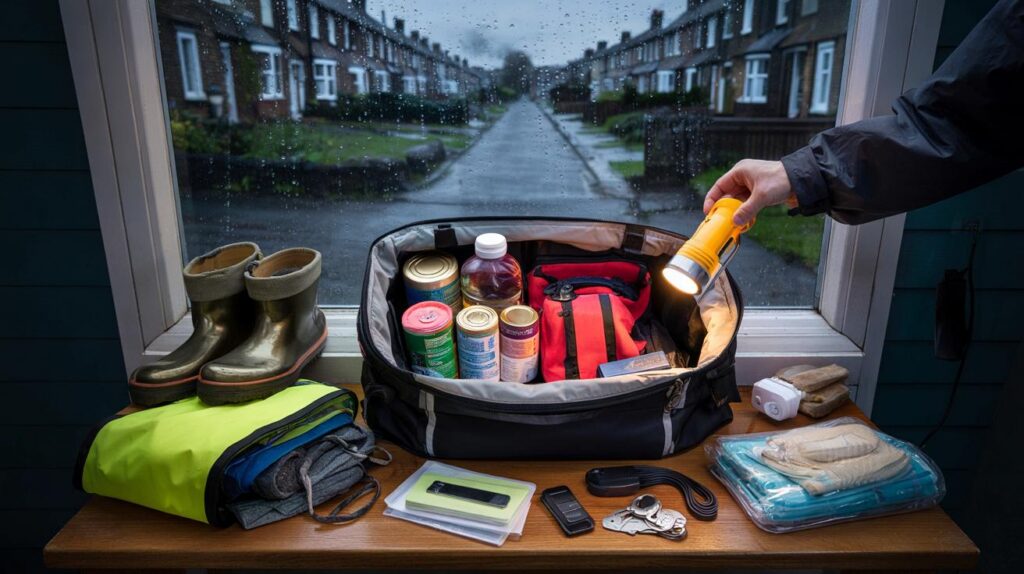
Build a grab-and-go kit before bedtime
The Met Office guidance is simple: have the basics in one place so you can move quickly if water rises or services fail. A small rucksack or a watertight holdall works well.
- Water and non‑perishable food for 24 hours
- First aid kit and any prescription medications
- Charged power bank, cables and a torch with spare batteries
- Warm layers, waterproofs, hats and gloves
- Copies of key documents and insurance details in a sealed bag
- Basic hygiene items and hand sanitiser
- Cash, house and car keys, list of emergency contacts
- Supplies for babies, older relatives or pets as needed
Keep the kit in one easy‑to‑grab spot and make sure everyone in the household knows its location.
If your home has flooded before, consider moving valuables and electronics upstairs this evening, rolling rugs out of harm’s way and checking drains and gullies for leaves. Park vehicles on higher ground if possible.
Travel and power: steps that cut your risk
Set off earlier than usual and slow down on wet roads. Increase the gap to the vehicle ahead and use dipped headlights in poor visibility. Avoid fords and lanes that frequently pond after rain. If you can, work from home during the worst of the morning band.
Check rail and bus timetables before leaving, as staffing and speed restrictions can cascade into knock‑on delays. Charge phones and laptops overnight, and keep a power bank topped up. Unplug non‑essential devices if water threatens ground-floor sockets. If you need to isolate electricity, do it only if you can reach the consumer unit without stepping in water.
Never drive through floodwater. As little as 15 cm can knock you off your feet, and around 30 cm can float a car.
Why a yellow warning still carries weight
A yellow warning signals a realistic chance of disruption somewhere within the highlighted area. The exact placement of the heaviest rain can shift by tens of miles as the system arrives, so short‑term updates overnight and at breakfast time can change the picture. Saturated soils, urban drains and high tides can all tip the balance towards faster surface water build‑up even under modest rainfall rates.
Warnings work in layers: check your local flood history, your street’s drainage and your commute’s usual pinch points. If your route crosses a known dip under a railway bridge or a low‑lying roundabout, plan an alternative now rather than improvising in the dark.
Thirty-minute home prep that pays off
- Lift floor‑level electrics and chargers onto tables or shelves.
- Clear leaves from doorstep drains and road gullies if safe to do so.
- Move the car to higher ground and avoid parking over drains.
- Pack pet carriers and leads by the door; put cat boxes together now.
- Photograph key rooms and valuables for any future insurance discussion.
- Set location alerts on your phone for your postcode to catch updates.
What the models say about the rain bands
Forecast models indicate several pulses of rain sweeping in from the south-west, with the most persistent segment tracking across Cornwall, Devon and into south Wales before edging into Bristol and Bath. Another arm may clip parts of the Midlands and the North West, with sharp showers separated by lulls. Small shifts in the jet stream position will decide which towns see the longest spell versus short, intense bursts.
If the rain aligns with the morning peak, expect slower traffic on the M5, A30 and A38, and spray affecting overtaking lanes. City routes in Cardiff, Swansea and Bristol that sit near rivers or have aging drainage could see fast‑forming puddles that block junctions and bus stops.
If water starts rising near you
Move people, pets and essentials upstairs or to higher ground. Place furniture on bricks or blocks if you have time. Keep children away from manhole covers and kerbside inlets where hidden currents can form. Avoid contact with floodwater; it often contains contaminants and debris.
When the rain eases, give drains time to catch up before heading out. Photograph any damage and keep receipts for emergency purchases. If you rely on medical equipment at home, call your provider now to discuss contingency power options.


Is Cardiff actually included in the 31 at‑risk areas or just flagged as ‘adjacent’? The list mentions south Wales and the watchlist names Cardiff, but the map focus seems more SW.