Colder air is on the march, and the first frost of the season could coincide with a sharp turn in travel fortunes.
Model-driven weather maps now flag a 24-hour window where snow showers may sweep all four home nations before November arrives, with the sharpest bursts flagged for late October. Temperatures look set to dip below freezing in places, raising the risk of early-season ice and slushy accumulations on higher routes.
What the latest maps show
Charts compiled by WX Charts using MetDesk data, guided by the GFS model, indicate a wintry spell from 27 October. Bands of snow showers look possible for England, Scotland, Wales and Northern Ireland, starting as cold rain at lower levels and turning wintry as the air mass cools.
The North East of England is one of the earliest candidates for flakes, especially over the North York Moors and the higher Pennines. Central Scotland and the Highlands carry a stronger signal, where showery pulses could deliver 1cm per hour at times on Sunday, increasing locally to 2cm per hour on Monday if bands align.
North and central Wales, including upland parts of Snowdonia, and higher ground in Northern Ireland are also in the frame where showers run in off the Irish Sea. Sheltered glens around Inverness could see the season’s first -1c overnight low, with a risk of ground frost more widely where skies clear between showers.
Forecast models point to a 24-hour window of wintry showers across all four nations, with peak snowfall rates up to 2cm per hour in parts of Scotland.
Where and when snow is most likely
- North East England: brief flurries over the North York Moors and northern Pennines late Sunday into Monday, mainly above 250–300m.
- Scotland: central high ground and the Highlands favoured from Sunday night, with bursts up to 2cm per hour and a chance of settling above 200–300m.
- Wales: north and central uplands could catch sleety showers turning to snow on higher routes, especially during heavier bursts.
- Northern Ireland: the Antrim Plateau and Sperrins may see wet snow at elevation as colder air digs in behind showers.
Why the pattern is turning wintry
The broader setup features a train of Atlantic lows pushing in from the west and south-west, bringing frequent showers and spells of rain. As one system clears, pressure is forecast to build over the Atlantic while lower pressure sits to the east of the UK. That shift encourages a north-westerly flow that drags in cooler, unstable air from higher latitudes.
In this pattern, showers form readily over the ocean, pick up moisture, then run into windward coasts and hills. Where the air column cools enough—helped by nightfall, altitude and heavier precipitation—rain can turn to sleet and snow, first on the tops and, during intense bursts, briefly to lower levels.
Colder north-westerly winds funnel showery bands into windward coasts; altitude, night-time cooling and heavier bursts tip rain to sleet and snow.
Temperatures, wind and visibility
Daytime values will hover near seasonal norms for late October, but windchill will bite in exposed spots. Overnight temperatures could slip below freezing where skies break, with -1c flagged for parts of the Scottish Highlands and close to zero in northern valleys. Gusty winds will accompany showers at times, and visibility will drop sharply in snow, sleet and hail.
Met office outlook in brief
The official outlook into early November points to a changeable, sometimes unsettled spell. Western areas are most likely to see the wettest conditions as Atlantic systems track towards the UK. Intervals of drier weather remain possible, but they look short-lived. Later, there are hints that southern counties could see a quieter interlude, which would increase the chance of overnight fog.
| Date | Region most at risk | Snow rate (peak) | Lowest temperatures | Primary hazards |
|---|---|---|---|---|
| 27 Oct (Sun) | NE England, central Scotland | Up to 1cm/hr | 0 to -1c in Scottish glens | Slushy coverings above 250–300m, icy patches overnight |
| 28 Oct (Mon) | Highlands, central belt hills | Up to 2cm/hr in showers | -1c possible Inverness area | Rapid changes in visibility, windchill on exposed routes |
| 29 Oct (Tue) | Wales uplands, NI high ground | Up to 1cm/hr in bursts | 0 to 2c widely, colder on high tops | Wet snow on passes, localised hail |
Travel and daily life: what to expect
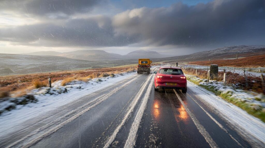
Short, sharp snow bursts can settle quickly on untreated higher roads, then melt between showers. That on–off cycle raises the risk of patchy ice after dusk and into the morning peak. The A9, A82 and trans-Pennine routes could see temporary slush, with longer-lasting cover possible over the Cairngorms and the highest fells.
Rail services can run slower through hail and sleet showers. Aviation sees the usual knock-on delays when visibility drops and crosswinds pick up. Rural communities above 300m may experience brief power flickers if heavy, wet snow loads cling to branches and lines, though widespread disruption is not indicated at this stage.
Brief, intense showers can lay snow faster than crews treat every route, so expect short-lived slush and a higher ice risk after dark.
How much might fall where you live?
Snowfall rates of 1–2cm per hour refer to peak intensity inside a shower band, not a continuous, day-long fall. Over 24 hours, most lowland areas will see little or no lasting accumulation. Uplands above 300–400m stand the best chance of a few centimetres, with locally higher amounts if repeated showers line up along the same corridor.
Surface temperatures matter. Early-season ground is relatively mild, so snow compresses into slush on busy routes while grassy banks hold a cover a little longer. After sunset, road surfaces can dip below 0c even when the air a metre above remains slightly positive, turning damp patches to ice.
Practical steps for the next 72 hours
- Plan higher-route journeys with extra time; keep screenwash topped up for hail and spray.
- Check tyre tread and pressures; pack a torch, warm layer and phone charger for longer trips.
- Grit steps and steep drives on Sunday evening if you live above 200–300m or in a frost hollow.
- Protect outdoor taps; check boiler pressure and radiator bleed to keep heating efficient in the cold snap.
- Keep an eye on updated local forecasts; shower tracks can shift 20–40 miles within a few hours.
A closer look at the signals
Guidance differs on how far south the coldest plume digs on Monday, and that uncertainty will dictate how widely snow is seen at low levels. A slightly more westerly track keeps heavier showers focused on western hills; a straighter northerly opens the door for North Sea streamers into the North East. Small track changes can double or halve local totals.
If you want a simple rule of thumb, watch the 850 hPa temperature (around 1,500m up). Values near -5c usually support snow to 200–300m in heavier showers. If precipitation intensifies, snow can briefly reach lower ground, especially overnight. When 850 hPa values sit nearer -2c, you are more likely to see sleet at low levels and snow reserved for the tops.
What comes next
As October turns to November, signals lean towards a changeable, often windy pattern with the west seeing the lion’s share of rain. There is a window for a quieter spell in the south as pressure builds, which would favour fog-prone mornings rather than snow. Even then, clear nights following showery days can still deliver patches of ice on untreated surfaces.
For hillwalkers and rural schools alike, the message is simple: short, punchy showers can surprise. A burst at 2cm per hour over a high pass makes for a tricky hour, even if the valley stays mostly wet. Keep plans flexible, prepare your kit, and watch how the shower lines evolve on the day.


Great rundown—thanks! If the GFS/WX Charts signal holds, do you expect the North York Moors to see settling snow above ~300m on Monday morning, or will ground temps just turn it to slush? I’m preppping the car (screenwash, shovel, blankets) but wondering if grit on the steps is overkill below 250m. Also, any update on shower alignment off the Irish Sea overnight?