Britain could flip from damp autumn to a wintry sting, with northern hills tipped for a sudden, short-lived blast of cold.
Computer models hint at a fast northerly incursion mid-October, with the Highlands most exposed. Early signals point to heavy bursts over higher ground, while many lowland towns juggle chilly rain, sleet and fog.
What the latest models show
Advanced GFS output, visualised by WX Charts and echoed on Ventusky, flags a window around 18–19 October when colder air digs south across Scotland. That feed of polar maritime air could collide with Atlantic moisture to trigger intense, wintry showers over the Highlands.
Model guidance indicates a short window on 18–19 October when snowfall rates could spike to around 5 cm per hour over higher ground.
Signals focus on the central and northern Highlands first, before snow showers drift north and west. The risk appears transient. It ramps up quickly, peaks, then fades as the air mass modifies or fronts sweep through.
Where snow could fall first
The early focus sits over Perthshire and Inverness-shire, with spillover to Ross and Cromarty later in the period. Elevation will make the difference between slushy surfaces and accumulating snow.
At-risk areas named by model maps: Perthshire, Inverness-shire, Ross and Cromarty — with the greatest chance above 300–400 metres.
Key hotspots flagged by model runs
- Perthshire: Cairngorm foothills and higher sections of the A9 corridor.
- Inverness-shire: Monadhliath and Cairngorm tops; showers blowing towards Inverness fringe as rain or sleet.
- Ross and Cromarty: Wester Ross hills, including higher passes, with coastal strips more likely to see rain.
How likely are 5 cm per hour bursts?
That headline rate reflects heavy convective snow showers over uplands, not a blanket across towns. Snowfall intensity on charts often translates from liquid-equivalent precipitation using a snow ratio. In early-season maritime air, the ratio skews wet, so even strong rates may struggle to stack up at low levels.
Brief pulses near 5 cm per hour can occur on plateaus and summits when the coldest pools clip Scotland. Road surfaces and marginal temperatures then decide what settles.
| Date window | Primary zone | Elevation most at risk | Expected intensity |
|---|---|---|---|
| 18 Oct (daytime) | Perthshire, Inverness-shire | Above 400–500 m | Bursts up to 3–5 cm/hr on peaks; sleet/rain below |
| 18 Oct (evening) – 19 Oct (early) | Ross and Cromarty, northern Highlands | Above 300–500 m | Scattered heavy showers; sharper accumulations on passes |
What the Met Office outlook adds
Into 8–17 October, forecasters point to a broadly westerly pattern, relatively mild nights and weak Atlantic fronts feeding rain or drizzle, mainly in the north and west. Many eastern districts trend drier for a time, with lighter winds as pressure builds from the southwest. Clear nights could bring fog patches and a cooler feel later in that spell.
From 18 October towards the end of the month, guidance shifts to more unsettled conditions returning countrywide. Successive Atlantic lows may bring frequent showers or bands of rain and, at times, stronger winds. Temperatures sit near seasonal norms, so marginal snow scenarios will hinge on brief cold snaps and elevation.
What this means for you
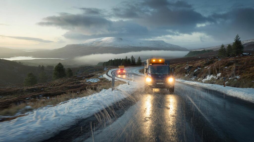
For most people in lowland Scotland and the rest of the UK, this signals a chilly, showery snap rather than widespread snow. The standout risk concerns higher sections of the Highlands, where fast-changing conditions can flip from drizzle to downhill whiteouts within a few miles.
Travel and power impacts to watch
- High routes: A9, A82 and exposed passes could see short-lived slush and reduced visibility in showers.
- Gusts: Windy spells later in the month may coincide with saturated ground, raising treefall risk.
- Grid: Wet snow on lines is possible over higher stretches, but any load should remain brief.
- Airports: Inverness and smaller Highland airfields may face shower-driven delays rather than long closures.
Why early-season snow can flip so quickly
October snow in Scotland usually rides on showery north-westerlies hitting cold summits, with a rain–snow mix lower down. Sea-surface warmth feeds the showers, but mild ground temperatures fight accumulation near towns. A single heavy burst can lay several centimetres on a high pass, then melt once showers ease.
Model snowfall rates come from converting predicted rainfall into snow using a ratio that depends on temperature and humidity. Maritime showers often produce wetter, denser flakes. That cuts depth compared with the same liquid in midwinter cold. It also makes roads greasy and visibility poor under headlights.
Signals, uncertainty and what to track next
Confidence strengthens on the broad pattern: a short settled window, then a turn back to unsettled, with colder shots brushing Scotland. The exact track of lows and the depth of the cold pool will decide whether showers turn to snow at 300 m or stay as cold rain. Small shifts in wind direction can move the shower stream by tens of miles.
For a practical guide, watch the 850 hPa temperature line, surface wet-bulb temperatures on hill routes, and the wind direction during the 18–19 October window.
Hillwalkers and drivers can prepare by planning for rapidly changing visibility and bringing winter layers earlier than usual. Local gritters typically stand up operations on a forecast of sub-zero road surface temperatures, but they may focus first on known hotspots and key arteries.
Extra context: what 5 cm per hour means on the ground
A rate near 5 cm per hour can briefly overwhelm untreated high routes, especially if it falls in a narrow, intense shower. On a salted surface, accumulation slows or turns slushy. If air temperatures sit just above freezing and ground temperatures lag, depth builds more slowly, often to 1–3 cm before compaction or melt.
For perspective, Cairngorm summits often see the season’s first settling snow in October. Lowland Perth and Inverness usually wait for deeper winter. This setup fits that pattern: lively showers over the tops, wintry fringes for glens, rain for most towns.
Jargon buster
- GFS: A global model that sketches broad patterns well in advance; local details improve inside five days.
- WX Charts/Ventusky: Map platforms that visualise model data; they are not official forecasts.
- Snow ratio: The conversion between liquid water and snow depth; early-season Scottish showers often run “wet,” reducing depth.
- 850 hPa temperature: A standard level aloft used to judge air mass; dips to around –5 C often support hill snow in Scotland.
What to do now
- Plan journeys across Highland passes with a margin for sudden showers and slower traffic.
- Pack a torch, warm layers and a scraper if you park overnight at elevation.
- Check localised forecasts inside 48 hours, as shower tracks can shift quickly.
- If you run a business above 300 m, review gritting and staff travel plans for 18–19 October.


So is this set to hit Perthshire first on the 18th afternoon, with Inverness-shire overnight into the 19th? I’m weighing an A9 drive—should I expect brief whiteouts over higher sections, or mainly slush with marginal temps? Any guidance on timing around 16:00–20:00 would help.
5 cm/hr sounds dramatic, but early-season setups are definately prone to overcook on model charts. Do you have any ground truth—Cairngorm AWS, A9 road sensors, or Met Office obs—to verify those spikes?