Forecasters see a sharp turn in October’s weather, with colder nights, lively fronts and early hints of mountain flakes.
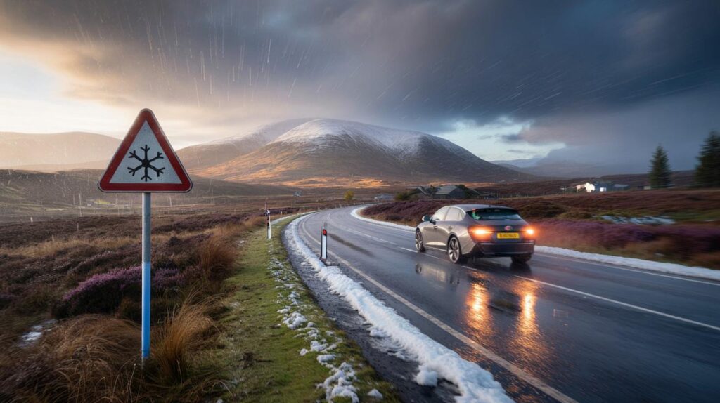
Forecast charts now point to the first meaningful shots of wintry weather, with Scotland’s highest ground in line for early snowfall. Many of us stay mild and damp at first, before a cooler, sharper feel develops as winds pivot and pressure patterns shuffle.
What models show for the next 10 days
Computer guidance flags a changeable set-up to begin with, steered by Atlantic fronts. These bring rain bands and bursts of strong wind, especially across northern and western hills. Nights stay relatively mild at first, thanks to cloud and breeze. Eastern districts hold onto brighter interludes between spells of rain.
By the weekend around 11–12 October, model fields suggest a pressure build to the west or southwest, while lower pressure takes hold towards the near continent. That shift pulls showers and brisker winds into more eastern parts, while the west and southwest pick up drier windows.
Up to 7.32 cm (2.8 inches) of snow is modelled over the Cairngorms on or around 12 October, according to WX Charts.
Scottish high ground in the firing line
Early-season snow tends to target the highest Scottish summits first, and current output fits that pattern. The Cairngorms and neighbouring ranges sit cold enough aloft for wintry precipitation when showers line up on a northwesterly flow. Road-level accumulations look unlikely outside the highest passes, yet tops and corries could whiten quickly in heavier bursts.
Expect a classic mix on exposed ridges: hail, graupel, sleet and brief snow, with rapid changes minute to minute. Any cover remains most likely above the highest tops, with wet surfaces and slushy edges below.
Why the 2.8 inches figure matters
The headline number reflects a modelled total depth, not a guaranteed hourly rate. In other words, a localised band could lay a couple of inches across the plateau over a day, but that does not mean 2.8 inches every hour. Short, intense showers can briefly lay down snow at speed on cold ground, yet the total accumulation depends on temperature, surface warmth, and how long showers persist.
The 2.8 inches signal is a potential daily accumulation on the highest ground, not a promise of continuous heavy snow.
How the pattern shifts across the country
The broad theme starts westerly, then tilts as pressure rebalances. Rain and drizzle favour windward coasts and hills. Breezier spells ride in with the fronts, while eastern districts see longer gaps between showers. Later, showers may bite further east as the wind veers and cooler air dips south.
Rain bands and wind focus
Fronts from the Atlantic deliver most of the week’s rain to Scotland, Northern Ireland, north-west England and Wales. Stronger gusts appear over high ground and adjacent coasts, with short-lived squally passages where the rain arrives in a line.
Cooler air and frost risk
As winds turn and skies clear at times, overnight temperatures drop. Sheltered rural spots could see a touch of grass frost by the second half of the period, especially in the north. The cooler feel helps showers turn wintry on the highest Scottish tops, though urban lowlands remain wet rather than white.
What this could mean for you
Most people face spells of rain, brisk winds and a cooler edge by day. Hillwalkers and drivers crossing the Cairngorms and other high routes should plan for sudden visibility changes and icy-feeling gusts. Power flickers remain possible in exposed rural corridors during squally showers, especially where trees still hold leaves in the wind.
- Commuters: allow extra time for rain-slick roads and spray on motorways, especially in the north and west.
- Hill travellers: pack layers, waterproofs, hat and gloves; expect wintry showers above the highest tops.
- Homeowners: clear drains and gutters to handle downpours; secure loose garden items before windy spells.
- Cyclists: watch for crosswinds on open stretches and leaf-fall slick on shaded bends.
- Parents: check school transport updates for upland routes if showers turn wintry overnight.
At-a-glance outlook by region
| Region | Dates | What to expect | Confidence |
|---|---|---|---|
| Scottish Highlands | 6–12 Oct | Rain and hill snow showers; 7.32 cm possible on highest Cairngorms around 12 Oct; windy on tops | Medium |
| Northern Ireland | 6–12 Oct | Frequent rain bands, breezy; brief brighter spells between fronts | Medium |
| Northern England | 6–12 Oct | Rain at times, strongest over Cumbrian fells and Pennines; cooler late week | Medium |
| Wales | 6–12 Oct | Unsettled with rain and hill fog; drier breaks later in the west | Medium |
| Midlands | 6–12 Oct | Intermittent rain, milder nights; turning fresher into the weekend | Medium |
| Southwest | 6–12 Oct | Showery start; better chance of dry windows later as pressure nudges up | Low to medium |
| Southeast and East | 6–12 Oct | Initially drier; showers and wind edge in later as the pattern tilts | Medium |
How to read these snow maps
WX Charts visualises data from major global models and presents projected totals and rates. These images help spot trends, but they are not official forecasts. Small shifts in wind direction or temperature aloft can halve or double hill snow outcomes. A model’s purple patch over the Cairngorms means the air over the plateau could support snow, not that every glen will turn white.
Accumulation maps often assume snow that reaches the ground settles. Early October ground runs warm after a mild spell, so some of the snow melts on contact. That difference explains why bold colours on maps do not always translate to deep cover underfoot.
Practical steps before the weekend of 11–12 October
Plan journeys with flexibility if you cross high routes such as the A9 near the Cairngorms. Check live road conditions before setting off. Pack a warm layer and a torch for evening commutes; sunset creeps earlier and showers reduce visibility fast. Gardeners can lift vulnerable pots under shelter to protect from gusts and downpours.
Hikers and photographers eyeing the first snows should carry a map, headtorch, spare gloves and a charged phone. Expect windchill to bite on exposed ridges. Mixed precipitation makes rocks greasy, so favour conservative route choices and early turnarounds.
Extra context on rates and risks
What would 2.8 inches an hour look like in practice? In a strong convective snow shower over cold ground, that kind of short-lived burst can blanket a summit in minutes. In early October, the atmosphere rarely stays that cold for long, so any intense phase tends to pass quickly. The most realistic outcome this time is a few centimetres added across the highest Cairngorm plateaus during repeating showers, interspersed with thaws between bursts.
Power lines and trees can struggle when heavy, wet snow clings above the treeline, but that risk usually arrives later in the season. The near-term hazards are more about gusty squalls, standing water on roads, and short periods of poor visibility in hail and sleet. Keep an eye on updated local forecasts as the weekend approaches, because small track changes in low pressure will shift the focus of showers east or west by tens of miles.


Is “2.8 inches an hour” just shorthand for a possible daily total on the Cairngorms, not an hourlly rate? Want to make sure I’m reading that right.