Pressure patterns are flipping, winds veer north-east, and a mid‑October cold snap threatens plans from school runs to hill walks.
Forecast models now hint at a sharper turn to wintry conditions than many expected, with higher ground in Scotland favoured for settling snow and some flurries drifting south. Northern England looks sodden under a slow-moving rain band, while a ridge brings quieter conditions to parts of England.
Where and when the snow could fall
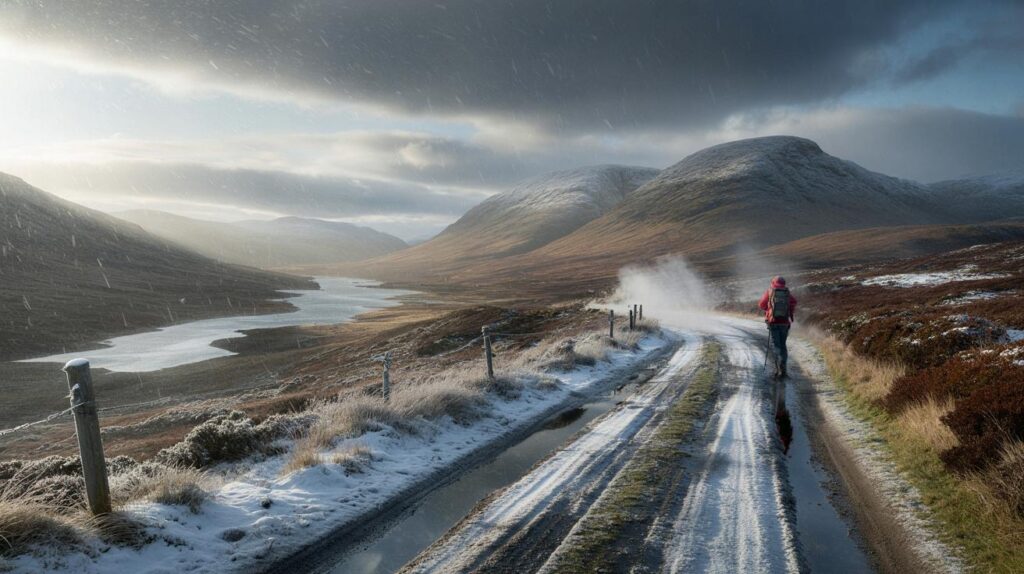
Signals cluster around the period from the middle to the late part of the month, with 21 October emerging as a notable risk window. The Scottish Highlands sit in the firing line first, with bands of showers setting in from the small hours and peaking between about 6am and noon. Elevation will matter. Settling snow becomes more likely above 300 to 400 metres, where air cools rapidly and the ground holds chill.
Up to 10 cm could build on higher slopes of the Scottish Highlands around 21 October, mainly above 300–400 metres.
Lower levels, including parts of Edinburgh and the Lothians, could catch flurries or sleet as showers pivot south. A slushy dusting is possible on higher suburban hills for a short spell, especially on grassy surfaces at daybreak. Separate projections also flag a small chance of a late‑October dusting across Snowdonia’s tops in North Wales if the northerly flow persists.
At the same time, northern counties of England face a soaking. A broad swathe of rain looks set to trundle south and east, refreshing already wet ground and raising the prospect of poor visibility and tricky travel for the morning commute.
Temperatures and wind
Air temperatures in northern uplands could dip to 0C or a touch above at dawn. Most towns sit a little higher, but the wind will bite. A keen north‑easterly sets a raw feel, while clearer breaks overnight allow frost to form in prone glens. Daytime values in the north hover near the mid‑single figures, with the south and south‑east a little milder.
Parts of the north could wake to 0C, with wind chill pushing it below freezing on exposed hills.
What the models are showing
WXCharts, drawing on MetDesk and GFS output, points to a colder feed building from the mid‑month. That aligns with guidance that pushes a ridge of high pressure towards the Norwegian Sea. The set‑up nudges winds around to the north and north‑east, drawing down colder air and picking up moisture over the North Sea. Showers then target eastern coasts and funnel inland along the wind. Netweather notes the same broad theme: higher pressure in charge for many, yet allowing coastal showers to clip eastern England at times.
Confidence on exact snow lines remains moderate at best. Early‑season warmth in the ground reduces settling outside higher terrain. A degree either side of freezing at dawn can flip outcomes from sleet to snow. Treat any snow risk for cities at low elevation as marginal and short‑lived.
| Region | Timing window | Precipitation | Max risk | Temperatures |
|---|---|---|---|---|
| Scottish Highlands | 21 Oct, 06:00–12:00 | Snow showers, heavy at times | 10 cm above 300–400 m | 0–3C (colder on peaks) |
| Edinburgh & Lothians | 21 Oct, morning | Flurries or sleet, then showers | Brief slush on higher suburbs | 2–6C |
| North Wales | Late Oct | Wintry showers on tops | Dusting above 600 m | 1–5C |
| Northern England | Around 21 Oct | Persistent rain | Surface water and poor visibility | 5–9C |
| Eastern England coasts | Next week | NE showers in onshore flow | Blustery, choppy seas | 7–12C |
Travel and daily life: what to plan for
- Check upland routes at breakfast; wet snow and ice can grip high passes above 300 metres.
- Allow extra time for rail and bus journeys; standing water and spray slow services in the north and east.
- Charge torches and phones; squally showers can cause brief interruptions in exposed districts.
- Test heating and bleed radiators before the first cold morning to avoid last‑minute call‑outs.
- Secure outdoor taps and move stock to sheltered fields on upland farms to reduce freeze damage.
Why this pattern is setting up
A ridge towards the Norwegian Sea shifts the steering winds. Air flows from higher latitudes, then gathers moisture over the North Sea. That cocktail breeds bands of showers that focus on eastern coasts and spill inland. Scotland cools quickly under clearer night skies, which primes the Highlands for early‑season snow while northern England sits under a more persistent rain shield.
How confident is the forecast
The chill looks credible, but track and timing will vary. Small changes in pressure placement alter wind direction and shower paths. A modest swing in temperatures at dawn decides whether snow sticks on grassy verges or washes away as sleet. If you live or work above 200–300 metres, keep plans flexible through the 21 October window.
Think elevation and exposure first: where air rises and cools, snow holds; where it sinks and dries, it fades.
Handy extras: wind chill and early‑season snow
Wind chill does not move the thermometer, but it strips heat from skin faster. A 2C morning with a stiff north‑easterly can feel several degrees colder. Dress for the feel, not only the number. Early‑season snow also behaves differently. Tarmac radiates summer warmth and resists settling. Grassy banks, peat and shaded lanes hold snow and ice longer. South‑facing slopes thaw first when the sun breaks through.
Five‑minute home and car checks
- Top up screenwash with a winter blend to cut through salt spray.
- Stash an ice scraper, de‑icer and gloves in the car for early starts.
- Set thermostatic valves to a low, steady level to protect pipes.
- Lay a door mat and tray to trap grit and meltwater from boots.
- Keep a small bag of grit or sand for steps that glaze before sunrise.
For hillwalkers and outdoor workers
Short days return quickly now. Pack a headtorch, a dry layer and spare gloves. Gusts on ridges bite hard in a north‑easterly, so plan routes with escape options. Expect freezing rain near the snow line at times. That can sheath paths and boulders with a thin, treacherous glaze. Check a mountain‑specific forecast the night before and again at dawn as shower tracks shift.


Will Met Office warnings cover the A9 and Cairngorm passes if the snow line sits around 300–400m on the 21st? Trying to decide whether to reschedule a dawn drive.
So the Highlands get 10cm and my garden in Leeds gets 10mm of soggy disappointment—classic British autumn 🙂