Grey skies have edged out late-summer warmth, and umbrellas are back on buses across the country as autumn barges in.
A strengthening low in the North Atlantic has forecasters watching the weekend closely, with changeable conditions stepping up from midweek. The Met Office has yet to name a storm, but attention now turns to whether “Amy” becomes the first of the season as rain bands and gusty winds line up.
What the Met Office says right now
Forecasters are tracking a deepening Atlantic low that could push across the UK late on Sunday into Monday. The system could bring a spell of heavy rain and blustery winds. Confidence on the precise track remains limited in midweek. The strongest signal points to the north of the UK for the most active weather, with changeable conditions elsewhere.
Before then, Monday and Tuesday offer the most decent breaks, with brighter spells and showers. From Wednesday, weather turns wetter and windier in many places. By Saturday, sunshine-and-showers looks likely, with a more organised area of rain trying to move into southern counties. The risk window for the nastiest weather sits between Saturday night and Monday morning.
The Met Office has not declared Storm Amy. The weekend system needs clearer impacts before a name is issued.
How the weekend could unfold
Current guidance suggests a lively setup. Shortwaves moving ahead of the main low could spin up bands of heavy rain and embedded thunderstorms. Coastal gusts could reach gale force if the low deepens quickly near the north-west. Inland winds look lower, but squally bursts may still disrupt travel.
| Period | Summary | Risk highlights |
|---|---|---|
| Wednesday–Friday | Turning unsettled, frequent showers, breezier | Local downpours, tricky driving on exposed routes |
| Saturday (daytime) | Sunshine and showers, heavier rain trying to edge into the south | Brief thunder possible; variable conditions hour by hour |
| Saturday night | Rain bands gathering from the west and south-west | Heavy bursts and squalls; small chance of thunder |
| Sunday | Widespread rain at times, turning windy, especially in the north and west | Gale-force gusts on coasts and hills if the low deepens |
| Monday | Blustery showers, sunny intervals between bands | Fallen branches, spray on roads, residual rail delays |
Who is most likely to feel the brunt?
Model trends favour northern Scotland, the Northern Isles, north-west Scotland, and parts of Northern Ireland for the strongest winds. Western coastal fringes of Wales and north-west England may also see punchy gusts if the low passes close by. Eastern and southern England look less windy in most scenarios, though a spell of heavy rain could still rattle through on Saturday evening or early Sunday.
Expect the most persistent rain and the stiffest gusts across the north of the UK, with changeable bands elsewhere.
Why the name “Amy” is on standby
For the 2025–26 season, the Met Office invited the public to submit names. “Amy” tops this year’s list and would be first in line if forecasters expect widespread impacts. A name arrives when the agency anticipates medium or high-end disruption, often aligned with yellow or amber warnings. The aim is simple: clear, memorable communication that helps people prepare and act.
Crucially, a name depends on expected impacts rather than wind speed alone. A deep low that brings 45–55 mph gusts to a densely populated corridor with saturated ground can warrant a name, while stronger but short-lived gusts in remote areas might not. That is why the team waits for clearer signals from the latest runs before pulling the trigger.
The backdrop: saturated ground and a busy spell of rain
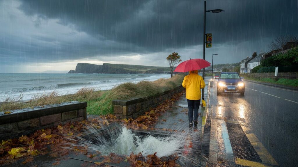
Many catchments already sit primed for quick surface runoff. The Environment Agency logged the wettest week in seven months across the country last week. The North West, South East and South West each recorded more than 35mm between 27 August and 2 September. Add falling leaves into drains and you create a mix that raises the odds of urban surface-water issues during intense bursts.
Short, sharp downpours can overwhelm gullies and roadside drains within minutes. Low-lying roads, underpasses and poorly drained retail parks tend to flood first. Rural lanes pick up debris, while high routes across the Pennines, the Cumbrian fells and Highland passes see crosswinds and sudden drops in visibility.
Last week delivered 35mm+ in several regions. Saturated soil means faster runoff and a quicker route to disruptive flooding.
What you can do today
- Check gutters, downpipes and yard drains, clearing leaves and moss before Saturday.
- Plan journeys with flexibility on Sunday and Monday, especially across exposed bridges and coastal roads.
- Secure loose items in gardens and on balconies ahead of any gusty spell.
- Keep a torch, charged power bank and warm layers in the car if you travel at night.
- Watch for updated Met Office warnings from Friday; timing and impacts can shift by a few hours.
Forecast confidence and what could change
The main uncertainty comes from the speed and depth of cyclogenesis over the North Atlantic. Small shifts in the track—100 to 150 miles north or south—can move the strongest wind zone and the heaviest rain. Ensemble models show a cluster pointing to a windy, wet Sunday in the north and west, with fewer members bringing damaging gusts into central or southern England.
If the low deepens near the Hebrides or the Northern Isles, gale or severe gale conditions could brush the most exposed headlands, with 50–60 mph gusts possible in a worst-case set-up. If it remains flatter, the UK still gets a lively autumn day, but disruption stays limited to short-lived, squally showers and poor visibility in rain.
How storm naming and warnings fit together
Storm naming comes alongside the colour-coded warning system. Yellow means some impacts are possible and you should review plans. Amber points to likely impacts, including travel disruption and a risk of power interruptions. Red is rare and signals danger to life. A name can arrive at yellow if impacts look widespread and confidence is rising, but most named events also feature amber warnings at peak.
Travel, sport and events: practical angles for the weekend
Long-distance rail and coach services often run, but heavy rain can slow speeds on exposed lines. Regional football and grassroots sport might face waterlogged pitches by Sunday morning in parts of the north and west. Outdoor events on coastal promenades and high ground should weigh wind exposure, especially for temporary structures.
Airports generally cope in windy conditions, yet crosswinds and downpours can force spacing between arrivals. Give yourself extra time at security and consider earlier departures if you have connections. Ferries across the Irish Sea and to the Hebrides can face choppy crossings; operators may change schedules late on Saturday.
Extra context that helps you plan
Deep Atlantic lows feed on temperature contrasts and jet-stream support. As seas retain summer warmth while Arctic air starts to sharpen, September often brings fast-moving systems. This setup can flip from quiet to stormy in a single model cycle, so refresh your forecast daily. If a name appears, it reflects rising confidence in widespread impacts, not hype.
Gardeners and allotment holders can use the wet spell to bed in autumn plantings but should stake taller stems and raise pots off patios to improve drainage. Runners and cyclists may want hi-vis layers and to route away from tree tunnels on Sunday. Dog walkers should pick sheltered paths if gusts freshen; falling twigs and acorns can spook pets.


Do we really need to name every blustery weekend? 50–60 mph on northern coasts is pretty normal. Feels like hype until warnings go amber.
Great heads-up—I’ll clear the gutters and tie down the garden bits on Fridday. Saturated ground + 35mm is a messy combo. Thanks for the pratical list.