Morning skies turn unsettled in the west as the east wakes to hazy sun, before evening promises a crimson lunar show.
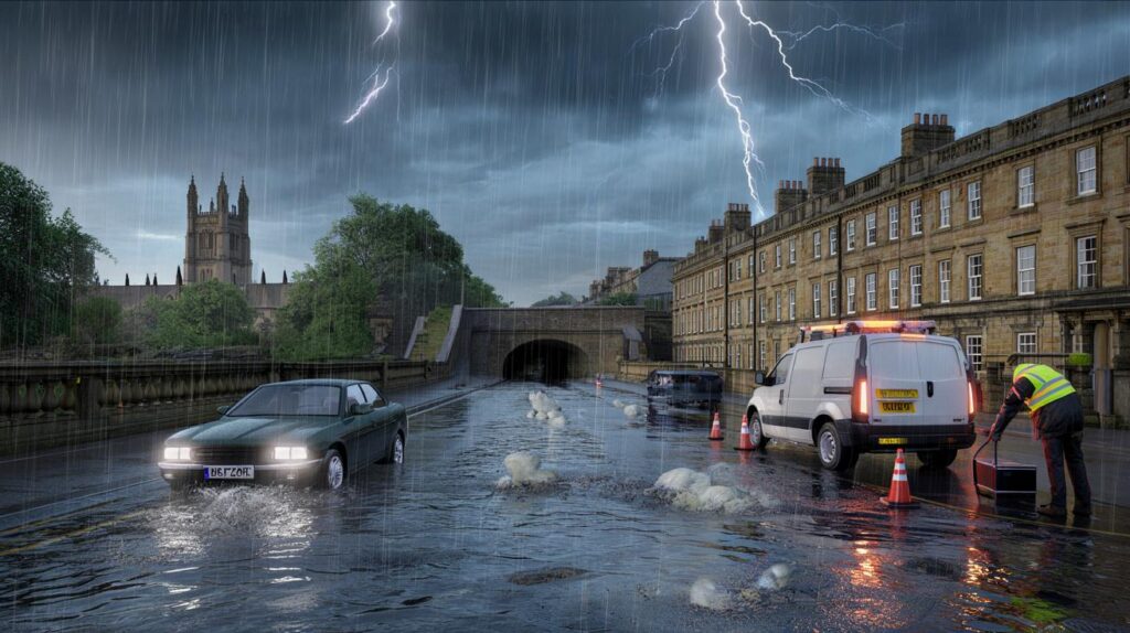
Forecasters have issued a yellow thunderstorm warning from just after 8am to midday, with intense downpours, lightning and hail.
Where and when the storms hit
Parts of Gloucestershire, including Gloucester, along with Bath, Salisbury and Newport sit in the warning zone this morning. A vigorous band of rain pushes north through late morning. The most active cells sit on that band’s leading edge. Some streets take a deluge while others nearby dodge the worst.
30–40mm of rain could fall in a short window, with frequent lightning and pockets of hail in the heaviest showers.
The yellow warning starts shortly after 8am and ends around midday. The most disruptive weather looks likely late morning as the rain band crosses urban routes and river catchments.
What to expect on the roads and rails
Drivers face spray, sudden standing water and reduced visibility. Short, sharp downpours can hide potholes and debris. Hail may rattle windscreens and make surfaces greasy. Lightning may cause brief power interruptions to traffic signals. Commuters should allow extra time for buses and trains as signalling snags and speed restrictions can follow thunderstorms.
- Slow down on wet stretches and increase the gap to the vehicle ahead.
- Avoid fords and flooded underpasses; water depth changes fast under heavy rain.
- Do not drive through moving floodwater; find another route.
- Keep a torch, phone charger and water in the car in case of delays.
- Check live service updates before leaving; platforms and depots can flood quickly.
Homes and businesses face a small chance of short power cuts and minor flooding, especially where gutters clog or drains back up under intense bursts of rain.
Expect local disruption, not a washout for all: the pattern is hit-and-miss, but where storms land, they hit hard.
Why the weather is split east to west
Western counties take the brunt this morning because the rain band feeds in from the south-west on strong winds. Coastal fringes in the west may see gale-strength gusts for a time, especially near exposed headlands. Farther east, brighter skies and hazy sunshine peek through during afternoon gaps, although a stray shower can still bubble up inland.
Meteorologists point to embedded thunderstorms within the broader rain, rather than a single organised squall line. That setup produces frequent lightning and short-lived hail, with rain intensity changing from street to street.
How the storm risk evolves through the day
The warning area sees the sharpest risk during the morning and late morning, then the heaviest rain edges north. Showers return from the south-west behind the main band. Sunshine follows in places, though wind stays lively near western coasts. Any water on roads drains slowly where leaves and late-summer debris block grates. Rivers respond more slowly, so watch for lingering high levels on smaller streams into the afternoon.
At a glance: today’s warning
| Area | Time window | Rainfall potential | Primary hazards | Possible impacts |
|---|---|---|---|---|
| Gloucester, Bath, Salisbury, Newport (and nearby districts) | Just after 8am to midday | 30–40mm in the heaviest bursts | Lightning, hail, strong gusts, intense rain | Slippery roads, surface flooding, power interruptions, transport delays |
What a yellow warning actually means
A yellow warning signals a risk of disruption for some, rather than a guarantee for all. It asks people to plan journeys with weather in mind. It also prompts rail, road and power networks to prepare for localised issues, such as brief faults or flooded sections of track. Amber and red sit above yellow when the likelihood and severity of impacts rise. Today’s setup sits at the lower tier but still deserves attention.
Who is most exposed this morning
Short urban commutes, school runs and weekend trips across the warning zone feel the sharpest effects. Low-lying roads, underpasses and routes with poor drainage flood first. Coastal paths and cliff-top walks in the west feel the wind and the spray. Rooftop terraces and scaffolding face risk in gusty pockets as storms pass.
Tonight’s bonus: a blood-red lunar eclipse
After the storms, the sky turns to spectacle. A total lunar eclipse is due this evening, with the Moon taking on a deep red hue around 7.30pm where skies clear. The Earth lines up between the Sun and the Moon, casting a shadow across the lunar surface. This will be the first total eclipse of the Moon visible from the UK since 2022.
You can watch safely with the naked eye. Binoculars or a small telescope add detail if clouds break. Western areas may still carry leftover cloud from daytime weather, so patience helps. Eastern districts stand a better chance of clearer slots, but cloud cover changes minute by minute.
Plan your evening around the skies
- Find an open view and give your eyes time to adapt to the dark.
- Pack a waterproof and a hat; showers can still pop up, even late.
- Use a red-light torch to preserve night vision if you bring a star map.
- Check the horizon often; breaks in cloud can be brief but rewarding.
Practical advice if thunder rumbles
Head indoors if you hear thunder. Avoid sheltering under isolated trees during lightning. Put metal ladders, golf clubs and outdoor tools away until the storm clears. Unplug sensitive electronics if lightning sits close by. Keep pets indoors to reduce stress from thunder.
If driving during hail or torrential rain, slow to a safe speed and use dipped headlights. Pull into a safe place if visibility collapses. Avoid stopping under bridges on fast roads; sudden braking creates added danger for vehicles behind. Never cross fast-flowing water on foot; find another way round.
What this means for the rest of the week
Soils drink a lot of water during short, intense bursts. That can send debris towards drains and culverts. Councils often clear problem spots after such mornings, but some puddles linger. Keep an eye on local river gauges if you live near a flashy stream. Gardeners can use the rain: barrels fill quickly today, and that buffers against drier spells.
For event planners and Sunday travellers, build flexibility into plans. The warning window covers a few hours, not the whole day. Many places enjoy bright gaps later. Forecasters will reassess through the day as new radar and lightning data arrive. If conditions improve faster than expected, delays unwind quickly. If storms redevelop on the trailing edges, brief fresh downpours may return near sunset.


Yellow again—are we talking brief flickers or actual power cuts in Gloucester? 30–40mm “in a short window” sounds rough. Do Western Power/SSEN have extra crews on standby to recieve faults between 8am and midday?