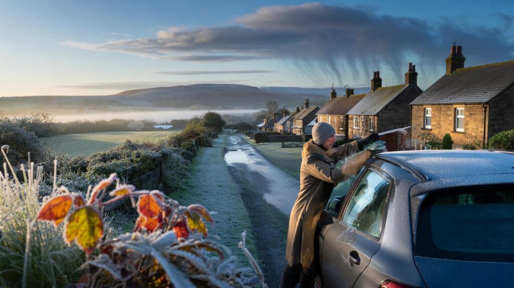
Clear skies and calm days hide a sharp turn ahead, with models hinting at a colder push as the month closes.
After a spell of settled weather, computer guidance points to a burst of much colder air late in October, with some places near freezing at dawn and the rest of us shivering in single figures by day. Weather maps built on MetDesk data suggest a brief window for hill snow in Scotland, while showers and rain bands nudge in from the west.
What the latest maps are signalling
Fresh runs from WX Charts indicate a notable dip in temperatures around 21–22 October as air of Arctic origin filters south. Northern England, Scotland, Northern Ireland and parts of Wales look most exposed to the sharpest chill overnight, with widespread 1–4C and pockets around 0C in rural spots. Urban centres stay a touch milder but still feel raw.
Model output highlights a pre-dawn minimum close to 0C in parts of northern Britain around 6am on 21 October, with frost risk in sheltered locations.
Alongside the drop in temperature, the same charts signal a rainy spell for many on the western flank. A few millimetres of rain could fall across the South West, Wales, sections of the Midlands and north-eastern coasts as pulses move through. Over the highest ground of central and northern Scotland, showers may turn wintry for a time, but any snow cover looks light and short-lived.
How cold, where and when
The coldest window focuses on the nights bracketing 21–22 October. Daytime readings widely sit in the mid to high single digits in the north and rise to near 10–12C further south, but a brisk breeze and showers make it feel colder. Valleys and glens could see a touch of grass frost where skies clear for several hours.
Expect single-digit daytime highs for most of the UK, with the earliest frost risk confined to northern hills and rural dips.
Why the pattern flips so quickly
High pressure has dominated recently, damping down winds, brightening the afternoons and allowing fog to form overnight. As that ridge slips away to the west, a northerly to north-westerly flow opens the door to colder maritime air. The jet stream sags south, guiding a sequence of weak fronts over the country. That combination brings colder nights, clearer intervals, and bursts of rain or showers between them.
Forecasters still note spread in the exact timing and depth of the cold pool. Small shifts in the track of the high will decide whether the core of the chill targets Scotland and northern England or taps a little farther south for a time.
At a glance: potential impacts
- Early frost risk in rural northern areas by 21–22 October.
- Brief hill snow possible over central and northern Scottish high ground.
- Patchy rain for the South West, Wales, Midlands and north-eastern coasts.
- Daytime temperatures mostly 7–12C, feeling colder in the wind and rain.
- Fog prone in sheltered spots either side of the fronts, with slow morning clearance.
Regional snapshot for the late-October dip
| Region | Likely overnight minimum | Precipitation risk | Most likely timing |
|---|---|---|---|
| Scotland (high ground) | 0 to 2C, below 0C in glens | Showers turning wintry on peaks | Night of 21–22 Oct |
| Northern England | 1 to 4C, locally 0C rural | Showery rain, brighter breaks | Early 21–22 Oct |
| Northern Ireland | 2 to 5C | Light rain or drizzle at times | 21 Oct |
| Wales | 3 to 6C | Bands of rain from the west | Evening 21 Oct |
| Midlands | 3 to 6C | Occasional rain, misty patches | Late 21 to early 22 Oct |
| South West | 5 to 8C | Frequent showers, breezy coasts | 21–22 Oct |
| South East | 6 to 9C | Mostly dry, a few light showers | 22 Oct |
What the Met Office outlook suggests
Official guidance indicates a largely settled spell in the near term under high pressure, with bright periods by day and chilly, sometimes foggy nights. Later in the month, an unsettled phase becomes more likely, bringing more frequent rain or showers and periods of stronger winds that could persist into early November. Temperatures trend close to seasonal norms overall, but clear nights increase the chance of local frost.
What it means for your week
Travel, schools and sport
Fog and a colder dawn could slow the early commute in prone valleys. Outdoor fixtures in the north may encounter wet, blustery spells, while higher Scottish routes might see sleety bursts for a time. Schools should prepare for playgrounds that are damp and chilly first thing, with layers needed for pupils spending time outside.
Gardeners and smallholders may want to protect tender plants in northern counties ahead of the coldest night. Campsites and mountain bothies could feel notably raw, with wind chill on exposed ridges.
How to prepare without overspending
- Bleed radiators and set thermostats to 18–20C for occupied rooms to avoid overnight chill.
- Check car tyres, lights and screenwash before early starts, especially where fog forms.
- Lag outdoor taps and short exposed pipe runs to reduce frost nip in rural spots.
- Keep a light waterproof and an extra layer to hand for school runs and evening activities.
- Look in on elderly neighbours ahead of the first colder night.
Uncertainty and what could change
There is reasonable confidence in a colder interlude, but the precise depth and reach depend on the track of fronts and the angle of the northerly flow. A slight shift west or east would change who gets the sharpest frost and who wakes to damp pavements instead. Keep an eye on updated local forecasts two to three days out for a tighter temperature range and any frost or fog advisories.
Beyond the first cold snap
As we move towards the final week of October and the start of November, signals favour a more changeable theme. That would mean alternating spells of rain and brighter intervals, with a couple of windier days possible as Atlantic systems pass by. In this setup, temperatures bounce around the seasonal average, but clear nights still allow for local frost where skies open briefly between fronts.
For context, brief October cold shots are common when a strong anticyclone retreats and the jet stream dips. The combination can produce sharp contrasts: sunlit afternoons under the high, then a punchier, showery airmass that quickly cuts temperatures once the flow turns northerly. Short-lived hill snow in Scotland during these events says more about altitude and air mass than the onset of winter proper, but it does mark the shift to coats, hats and slower mornings.


Thanks for the heads-up—frost risk by 21–22 October is earlier than I expected. Will this be enough to threaten tender plants in the Midlands, or is the core chill staying north?
Every autumn we get “arctic blast” headlines and then it’s 9C and drizzle. What confidnce do you actually have in those WX Charts vs Met Office guidance?