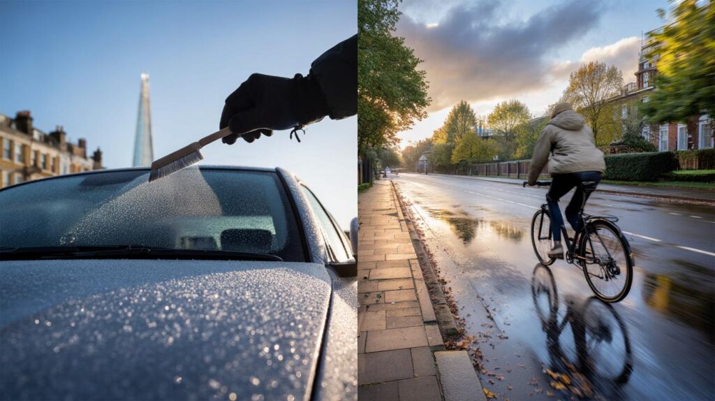
Frosted windscreens, shivery dog walks and a dusting of hill snow marked a biting weekend across parts of Britain. Now, commuters brace for another twist as the week unfolds.
After a brief burst of Arctic air, forecasters signal a flip towards milder Atlantic weather. Temperatures rise steadily, with a notably gentler feel by Friday.
From Arctic nip to Atlantic lift
Saturday brought flakes for some high ground and wintry showers on exposed coasts. By Sunday night, the far north flirted with 0C as frost settled in sheltered spots. Early Monday kept the chill, yet a different pattern now edges in from the southwest.
Very mild air pushes in late week, lifting daytime values into the low to mid-teens, peaking near 15C in the southeast.
Meteorologists describe a clear handover. The cold pool lingers into midweek, but a milder, moisture-laden Atlantic flow replaces it from Friday. The contrast will feel stark if you’ve spent the past two mornings scraping ice.
How the week rebuilds
Temperatures you’ll actually feel
Daytime readings trend upwards through the week. Many towns return to 11–14C by Thursday. The southeast could nudge 15C on Friday and again on Saturday. Sunday looks broadly cooler, around 10–13C, as a new area of low pressure shuffles bands of rain across the country.
Expect a step-by-step recovery: chilly starts, milder afternoons, and a warmer pulse by the weekend.
Rain and wind on the way
Low pressure dominates the changeover. Showers become widespread, with longer spells of rain at times. Western hills stand to collect the largest totals. Breezier conditions build, and some coasts face the risk of gales as systems sweep through.
Between those systems, short brighter windows appear. These clearer gaps may allow fog and a touch of frost overnight, especially in rural valleys.
Regional picture at a glance
- Scotland and Northern Ireland: Coldest nights early in the week, turning less raw from Thursday; showers frequent in the northwest, wintry over the highest tops at first.
- North of England: Frosty dawns fade midweek; showers spread in from the west; breezy on coasts.
- Midlands and Wales: A slow thaw in feel; bursts of rain, heaviest over western uplands; brief sunny spells between fronts.
- South and southeast: Noticeably milder by Friday and Saturday, up to around 15C; bands of rain and drizzle at times, but also drier interludes.
Day-by-day guide
| Day | South-east highs | West and Wales highs | Northern highs | Headline risk |
|---|---|---|---|---|
| Wed | 11–13C | 10–12C | 8–11C | Scattered showers, cool breeze |
| Fri | 14–15C | 12–14C | 10–13C | Milder air arriving, rain bands |
| Sat | 14–15C | 12–14C | 10–13C | Unsettled, breezy at times |
| Sun | 11–13C | 10–12C | 9–12C | Showers or longer rain |
Why the flip is happening
This swing hinges on air mass origin. Over the weekend, northerlies delivered polar air straight down the spine of the UK. That flow slackens and bends west. Atlantic systems then ferry in milder, maritime air. Sea-sourced air holds more moisture and greater cloud cover, which caps overnight frost yet raises the chance of rain.
The jet stream steers the parade of lows. When it dips south of Britain, colder air seeps in from higher latitudes. A nudge north drags in milder air and stirs up blustery, unsettled spells. This week’s nudge favours the latter.
What this means for your plans
The school run, training sessions and the big shop
- Morning routine: Frost risk fades after midweek, but patchy fog is possible in clearer breaks. Leave extra time if your route crosses valleys.
- Outdoor exercise: Layers still help early on. By Friday, a thin waterproof will beat a bulky coat as showers arrive.
- Home energy: Heating demand likely eases late week. Consider shorter boiler timings as daytime values climb.
- Weekend events: Expect interruptions from rain bands. Keep a brolly and plan for gusty spells near coasts and hills.
Signals beyond the weekend
Guidance for the period through to early November keeps the UK in a changeable zone. Low pressure patterns dominate. Showers or longer outbreaks of rain affect most areas. The west carries the highest rainfall totals, driven by onshore winds and uplift over hills.
Risk flags: heavy rain at times, strong winds with local gales, brief dry slots between systems, fog and a touch of frost overnight in clearer breaks.
Temperatures trend close to, or a shade above, the seasonal average. That implies fewer sharp frosts than recent nights, yet no settled warmth. Any mild surge will ebb as the next front rolls in.
Practical pointers for the days ahead
Flood risk remains localised but watch western river catchments where pulses of rain line up. Urban surfaces may briefly pond during heavier bursts. Motorways and higher routes can turn slippery with leaf fall and spray, so extend braking gaps.
Gardeners should make use of Friday’s milder air to lift tender pots under cover and clear drains before the wetter push. Walkers heading for uplands may still meet a wintry nip over the tops early in the week; later, expect claggy cloud, brisk winds and soggy paths.
A quick sense check on numbers
Minimums earlier in the week hover a few degrees above freezing for many, dipping to near 0C in the far north under clear skies. Daytime highs recover to 11–14C for a broad swathe by midweek. The south and southeast most likely touch 15C on Friday and Saturday, softening the feel dramatically compared with Sunday night’s frosts.
If you’re weighing up wardrobe choices, think in phases: gloves for early mornings through Wednesday, lighter layers for Thursday, and a packable rain jacket from Friday as milder air meets incoming fronts.
For Halloween plans on Friday, milder air helps comfort for trick-or-treaters, but brief rain bands and a fresh breeze may shuffle timings. Keep costumes dry with a thin waterproof layer and choose brighter routes if fog lingers after dusk.
Looking slightly further afield, an active Atlantic keeps the conveyor running into early November. That brings pros and cons: better daytime comfort and fewer icy starts, but more frequent spells of wet, windy weather. If you manage travel, delivery rounds or outdoor shifts, a flexible plan will pay off—check local forecasts on the morning, then again mid-afternoon as fronts sharpen or weaken on approach.


Thanks for the clear explainer—feels like a proper step-by-step recovery. I’ll definitley swap the big coat for a light waterproof by Friday.
15C by Friday—confident call or just a warm blip before the next front? How many model runs back this, ECMWF and GFS both?