Snow on the way, and not the flimsy kind. Forecasters have nudged their maps and numbers again, lifting the risk and shifting the line between slush and proper powder. Up to 4 inches could fall in a few hours across parts of the UK, with the morning rush right in the crosshairs. Gritters are out early, airports are watching thresholds, and parents are quietly juggling Plan B. The warning is simple: conditions may change fast, just as plans do.
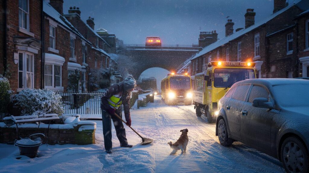
The windscreen fogs the minute I step in, a milky film that makes the cul-de-sac look like a postcard gone wrong. Down the street, a neighbour smacks ice off a wiper with a mittened fist, the sound like a cracked knuckle in cold air. Somewhere a radio mutters about a “wintry mix,” while the dog refuses the first patch of pavement. Phones ping with texts from people who never text this early. The headlines don’t shout; they nudge. The map changed overnight.
Snow upgrade: where and when it lands
Forecasts across the UK have been revised, with a fresh band of snow now expected to lay down around 4 inches in a narrow corridor. The line stretches in snapshots: higher parts of Wales and the Midlands, a stripe into northern England, and some eastern districts where North Sea air does its trick. Timing matters. A Thursday-style wake-up could be white for many, with the snowline dipping lower for a few precious hours before lifting. That window is the one that catches tyres, buses, and school gates.
If you want a human scale, think of the 7:42 train that became a cold platform queue last time the flakes got cheeky. A delivery driver in Sheffield told me he missed two drops on a single estate because one hill turned into glass in ten minutes. In past bursts, Met Office maps showed a one-inch dusting that doubled on the ground when the air turned just a notch colder. At snowfall rates near 1–2 cm per hour, four hours is all it takes to bury good intentions and fill verges.
Why the change? Small shifts in dew point and the track of a shallow low can flip rain to snow in a heartbeat. Wet-bulb cooling turns falling flakes into a local fridge, dropping temperatures at street level just when school runs begin. Model guidance often disagrees until the last 12–24 hours, then snaps into alignment with a sharp snow stripe and a broader field of sleet. Elevation and exposure add the final twist. That’s why you might get **4 inches** on one side of a town while the other side just gets wet feet.
Getting through the next 48 hours
Keep it simple and boring, because boring wins. If you’re driving, set off ten minutes early and treat every input like it’s connected to porcelain: second gear pull-away, feather-light throttle, and a long look up the road. Clear the roof as well as the screen; snow slides become surprise blindfolds at 30 mph. For de-icing, go with proper spray or a plastic scraper. Warm water can crack glass when frost is mean. Pack a small bag: gloves, charger, bottle of water, a snack, and a torch that actually works.
We’ve all had that moment when the dashboard lights up, the rear wheels twitch, and you realise your big plan was a bit optimistic. Let kids wear boots instead of trainers and swap the fashion jacket for layers you won’t regret. Cyclists: drop tyre pressure just a touch and go fatter if you can. Pedestrians: watch for the sheen under streetlamps; that’s the trap. Let’s be honest: nobody does this every day. Do the small things, then forgive yourself for the rest.
There are two myths worth ditching: that 4×4 means invincible and that ABS shortens stopping distances on ice. Four-wheel drive helps you go, not stop. And ABS keeps the wheels turning; it doesn’t create grip from nowhere. Morning commute plans should include a Plan B, even if it’s just a slower route with fewer hills.
“Forecasts evolve right up to the wire,” said one senior forecaster. “An extra half-degree at 200 metres can turn drizzle into a snowburst.”
- Check live warnings before bed and again at breakfast.
- Clear all windows, mirrors, and lights — you need the full picture.
- Leave space: aim for a 10-second gap on open roads.
- If you lose traction, steer straight and ease off, don’t stamp on the brakes.
- Keep a small bag with essentials and a bright hat for visibility.
What this cold snap says about our winter
Every few winters we’re reminded how thin the line is between routine and weather story. In a maritime climate, the cold is rarely Siberian; it’s marginal, messy, and full of last-minute swerves. That’s precisely why revised predictions matter more than a bold early headline. They sharpen the hour, tilt the snowline, and nudge decisions that ripple through workplaces, classrooms, and doorsteps. It’s not drama for drama’s sake. It’s the lived reality of small degrees.
Communities get inventive when the flakes stack up. WhatsApp groups turn into road reports, strangers push cars with their shoulders, and local cafés become warm hubs with fogged windows and laughter. Schools weigh safety with learning, buses crawl, and a pile of wet gloves appears near every radiator. Winter asks for patience we don’t often practice. A picture from your street — a bench half-buried, a wheelbarrow with a white hat — tells its own tiny truth. That’s the story worth sharing.
| Key points | Details | Interest for reader |
|---|---|---|
| Up to 4 inches likely in a narrow band | Models upgraded the snow risk overnight; short, intense bursts | Know if you’re in the stripe or just outside it |
| Timing targets the commute | Pre-dawn to late morning window for key routes and school runs | Plan journeys, childcare, and deliveries around the peak |
| Marginal temperatures drive big swings | Wet-bulb cooling and elevation move the rain/snow line fast | Avoid surprises by checking updates close to travel time |
FAQ :
- Where is most at risk of 4 inches?Higher parts of Wales and the Midlands, pockets of northern England, and some eastern districts exposed to North Sea showers. Low-lying coastal strips are more likely to see sleet or slushy cover.
- When will the worst hit?Expect the most disruptive window around the early commute, with some areas seeing a rapid onset before breakfast and easing by late morning. Evening refreeze may follow.
- Will roads and rail be affected?Yes, in the snow stripe. Hills, untreated side roads, and motorway ramps are the weak spots. Rail delays tend to cluster where points and overhead lines meet heavier bursts.
- Could schools close?It depends on local conditions. Heads make the call early; watch school apps and council pages. Even open schools may stagger start times if pavements are icy.
- How can I track late changes?Check official Met Office warnings and your local council gritting updates. Use live radar to see the snow band’s shape — look for bright echoes tightening along that risk corridor.


Any clarity on exact timing for SE London? The piece flags the early comute, but are we talking pre‑6am or closer to school run at 8? If temps are marginal, a half-degree swing will matter. I’m seeing mixed signals on Met Office vs. MeteoBlue—have they definately aligned thier updates yet?