Met Office alerts are shifting, gritters are rolling, and the word nobody quite believed last week is suddenly back on the agenda: snow. Forecasters have revised their predictions and now say parts of the UK could see up to four inches, with a sharper push of Arctic air and bands of snow showers lining up from the north and east. That means slippery pavements, twitchy morning commutes, and a lot of people staring at the sky, trying to judge whether those grey clouds are just sulk or intent.
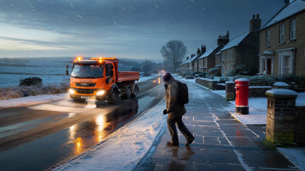
The first sign something had changed came quietly, before dawn. A lone gritter rattled down a usually sleepy street in Wakefield, amber lights combing the drizzle as if it were already snow. By breakfast, the group chat had moved from memes to logistics: who’s got spare salt, which school tends to close first, is the 7.42 running if the platforms glaze. It felt like winter had swivelled its gaze in our direction again, fast and serious. The maps changed overnight.
UK snow warning: what changed, who’s in line, and how much is coming
Forecast models nudged colder as a deeper slice of Arctic air hooked into the flow, and that tweak matters. It turns marginal rain into slushy snow, and slush into the proper stuff that sticks. **Up to four inches of snow are now on the cards for parts of the UK**, especially over higher ground in Scotland, northern England, the Pennines and the North York Moors, with a wintry mix possible for lower levels too. The Met Office yellow warnings focus on snow and ice, the kind that comes in pulses: dark horizons, a flick of flakes, then thirty minutes later the world looks rinsed and rearranged.
A council depot manager in Aberdeenshire told me they’d doubled night shifts after radar showed showers lining up down the Moray Firth like train carriages. In Cumbria, a postie said they’re swapping to boot spikes for first deliveries, because the cut-through behind the chemist turns to glass after sunset. The pattern looks classic: showers feeding off the North Sea and Irish Sea, drifting inland, merging into heavier spells where the wind funnels along hills and river valleys. Temperatures are set to dip below freezing in many spots at night, with a biting wind making minus two feel like minus eight on exposed platforms and hill roads.
Why the late shift? Small-scale features did the heavy lifting. A subtle trough strengthened over cold seas, boosting the “engine” for snow showers while dew points fell just enough to flip sleet to snow away from coasts. Inland, night-time clear spells will let heat leak skyward, priming roads and pavements to glaze when showers pass. The North Sea fetch has also lengthened on the models, raising the risk of narrow snow streamers for parts of northeast England where accumulations jump in a matter of hours. Call it 10 centimetres in old money for higher routes, with 1–3 centimetres more typical in towns that catch a few lively bursts.
Staying one step ahead of a suddenly snowy day
There’s a neat 20-minute routine that pays off. Check the Met Office app or your preferred radar at the kettle’s first boil, then choose your route with altitude in mind, not speed. Clear the windscreen fully, including the wiper wells and the roof — a sheet of roof snow is a headwind hazard once you hit 30 mph. Layer up: thin base, warm mid, weatherproof shell. A 20p coin test on tyres takes seconds; if you can’t see the outer band on the coin when it sits in the tread, grip is still decent for the slippy bits.
Think friction, not force. Slow steering and early braking beat heroic rescues, and a gentle second gear start can stop spin on icy pull-aways. Don’t throw hot water at a frozen windscreen — it cracks glass and leaves a slush glaze — use de-icer and the car’s vents set to warm, not full blast. We’ve all had that moment when the pavement looks fine and then a heel shoots out as if tugged by a prankster. Lay a small mat or a bin bag at your front step for grip on the first footfall. Let’s be honest: nobody actually does that every day.
Local pros are reading the sky the same way you are, just with better radios and salt piles. A gritter driver near Hexham put it best:
“If the showers start lining like soldiers on the radar, we’re out early and we’re out twice. It’s the narrow bands that catch folks by surprise.”
**Travel disruption is likely where showers band together into longer spells.** Below, a pocket checklist for the glovebox and the backpack — the small things that turn a messy morning into a manageable one:
- Lightweight scraper, de-icer, and a microfibre cloth
- Head torch, spare socks, thin gloves you can text with
- Folded hi-vis, foil blanket, compact power bank
- Snack with protein, small water bottle, a fiver in coins
- Printed phone numbers in case your battery dies
What this cold snap says — and what might come next
Snow does this peculiar British thing of feeling both rare and deeply familiar, and that’s part of why a model tweak can set off a national reshuffle of plans. Jet stream wobbles and sea temperatures nudge the dice for short, sharp winter bursts like this one, then the local geography decides who wins or loses the flake lottery. Communities reappear in small acts — a borrowed shovel, a spare lift to work, a bin put back upright — while the rest of us refresh radar apps like they’re football scores. *Snow has a way of slowing even the busiest city to a hush.* **This is a short, sharp snap — not a weeks-long freeze** — but it’s a timely reminder that a few degrees, one overnight pivot, and the week you thought you had can look very different by breakfast.
| Key points | Details | Interest for reader |
|---|---|---|
| Up to 4 inches possible | Highest totals over hills in Scotland, Pennines, North York Moors; 1–3 cm in lower spots under heavier showers | Know if your area may see proper settling snow |
| Warnings revised | Met Office yellow alerts for snow and ice as Arctic air deepens and shower bands strengthen | Plan commutes, school runs, and deliveries with fresh info |
| Short, sharp cold snap | Risk peaks as showers align; nighttime ice widespread with sub-zero feels-like temperatures | Time your travel and reduce slip-and-slide risk |
FAQ :
- Where is most likely to get the 4 inches?Upland areas in Scotland and northern England stand the best chance, with localised boosts under persistent snow streamers off the North Sea.
- Will it settle in cities?Lower levels may see slushy coverings during heavier bursts, especially after dark and on untreated surfaces, but totals are likely smaller and patchier.
- When will travel be trickiest?When showers align into longer spells and overnight into the morning rush, as refreezing turns wet patches to stealthy ice.
- Should I drive or work from home?If your route climbs or crosses known snow belts, consider delaying until after gritting runs and daylight; flat, urban routes may be manageable with care.
- What does “revised predictions” actually mean?Models picked up a colder, showery signal late on, shifting the rain–snow balance and increasing the risk of accumulations in exposed regions.


Four inches? Time to panic-buy bread, milk and sledge wax 🙂