A sharp late-October pattern change is lining up, drawing colder air across the British Isles and nudging temperatures towards their first frost.
Forecast maps point to a fast, punchy burst of snow across every Home Nation, with the most persistent bands targeting higher ground and exposed coasts.
What the latest model runs show
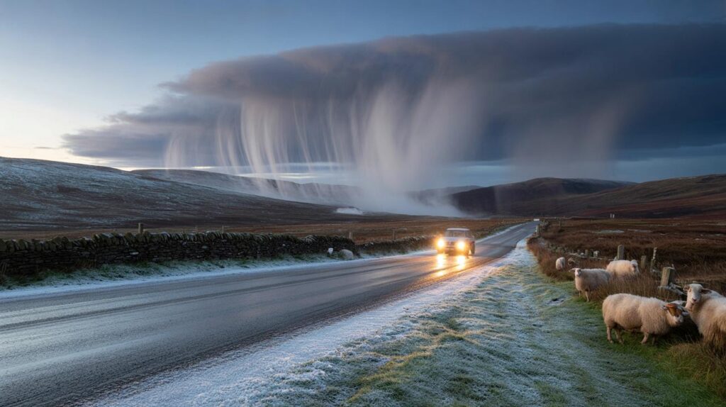
High-resolution maps from WX Charts, using MetDesk data based on the GFS model, show a 24-hour window for snow showers around Sunday 27 October. The signal covers Scotland, Northern Ireland, Wales and parts of England as a colder northwesterly feeds in behind low pressure. The North East of England looks primed for coastal streamers, while central Scotland and the Highlands draw the steadiest accumulations.
Model guidance indicates snowfall rates near 1cm per hour at times on Sunday, with short spikes to around 2cm per hour over Scottish uplands as air turns colder and instability deepens. The coldest pockets in Scotland, including the Inverness area, may dip to around -1C overnight, with ground temperatures lower on sheltered grass.
Up to 24 hours of snow showers are possible on 27–28 October. Peak rates near 2cm per hour could clip Scottish hills, with -1C lows likely in the north.
Further south, a mix of sleet, hail and wet snow is possible over the North Pennines, the Yorkshire Moors and higher parts of Wales. Northern Ireland sits on the western flank of the feed and may see brief bursts, mainly over the Antrim Plateau and the Sperrins.
Who is most likely to see snow
The set‑up favours showers aligned to the wind flow off the North Atlantic and, for eastern England, across the North Sea. Elevation tilts the odds, especially during the daytime when marginal temperatures meet relatively warm ground. Night-time and early morning offer the best chance for settling snow below 300 metres.
- Scottish Highlands and Grampians: frequent showers, local 2cm/hr spikes; slushy cover possible below 300m, better settling above 400m.
- Central belt fringes and southern Uplands: occasional showers, mainly sleet at low levels, wet snow above 250–350m.
- North East England and North Pennines: coastal streamers for the Tyne–Tees stretch; slushy cover on hills, hail/graupel to sea level.
- North and central Wales: Snowdonia and higher mid‑Wales favoured; wet snow above 300–400m, wintry mix lower down.
- Northern Ireland: brief bursts over higher ground; limited low‑level settling.
How this compares with a typical October
October snow in the UK is unusual but not rare, and most events are short‑lived. Early‑season showers arrive when a cold maritime airmass follows an autumn storm and land temperatures lag behind the atmosphere aloft. Accumulations tend to favour grassy surfaces and shaded lanes, with main roads staying just warm enough for slush to turn back to water during the day.
Early frosts often arrive in the last third of October, first in northern glens and rural valleys. This setup fits that pattern: a brisk northwesterly, scattered showers, and a brief dip below zero in the north overnight. Strong October sun angles are gone, but residual ground warmth still limits the depth and duration of cover away from the hills.
What the Met Office outlook suggests
The official outlook through late October keeps the theme of low pressure arriving from the west or southwest, sending further spells of rain and showers with occasional strong winds. Between these, shorter dry breaks pop up before another frontal wave moves in. Temperatures look near seasonal for many, but day‑to‑day values will swing with each low’s track and timing.
Late in the month, guidance leans towards a slightly cooler, showery northwesterly as high pressure firms up over the Atlantic and low pressure sits to the east. Early November trends changeable, wetter in the west, with a small chance of brief, quieter spells in the south that could allow overnight fog.
When and where to expect the worst
| Region | Most likely window | Typical rate | Lowest temperature |
|---|---|---|---|
| Scottish Highlands | Sun PM to Mon AM | 1–2cm/hr in bursts | -1C to 1C |
| North East England | Sun afternoon/evening | Up to 1cm/hr in showers | 0C to 2C |
| North and central Wales | Sun evening to night | Up to 1cm/hr on hills | 0C to 2C |
| Northern Ireland | Sun night | Light, brief bursts | 1C to 3C |
Travel, power and daily life impacts
The short duration limits serious disruption, but timing matters. A Sunday night to Monday morning window brings the school run and commute into play, especially where slush refreezes. Rural routes over passes in Scotland, northern England and Wales may turn slippery. Leaves on the line and wintry showers can slow some rail services, and exposed bridges could see gusty sidewinds as showers move through.
Even 2cm per hour, if repeated in showers, can cover untreated surfaces quickly and produce patchy ice by dawn.
Power supplies rarely suffer from early‑season events, though heavy, wet snow sticking to lines and branches at a narrow temperature range around 0C can trip minor faults. Most airports should operate normally, with only brief de‑icing required during the overnight period.
What to do now
- Check an updated local forecast on Saturday night for the hour‑by‑hour timing where you live.
- Plan an extra 10–15 minutes for Monday morning travel if you cross high routes or rural lanes.
- Keep a scraper, torch and warm layer in the car; top up washer fluid and check tyre tread.
- For hills, switch to sturdy footwear and carry microspikes if you head above 400m.
- Move vulnerable pots under cover and clear outside drains to reduce standing water that can freeze.
Why showers, not a blanket of snow
This event is driven by convection rather than a large frontal snow band. Cold air aloft passes over comparatively warm seas, building towers of cloud that come ashore as squally showers. Where lines of showers align with the wind, they “train” over the same spot. That is how local totals can grow while a town 10 miles away stays mostly dry.
Snowline matters. Through the daytime, expect a snowline near 300–400m in the north and 400–500m in Wales and northern England. At sea level, expect hail or graupel mixed with rain, with brief whitening in heavier bursts that melts quickly. After sunset, the snowline can dip by 100–200m for a few hours, especially in sheltered glens and valleys.
What 2cm per hour really means
Rates near 2cm per hour describe the intensity within the shower, not a steady blanket. Three or four strong showers could deliver 3–6cm on a hill above 400m, while nearby low‑lying areas get little more than slush. Grassy verges and untreated pavements take it first; gritted A‑roads usually stay wet.
What could change next
Small shifts in wind direction make a big difference to who sits under a shower band. A degree or two of sea‑surface to air‑mass contrast also changes intensity. Keep an eye on Saturday evening model runs: a nudge more northerly boosts North Sea streamers into the North East; a touch more westerly favours north and central Wales and the Irish Sea coasts.
Looking ahead to early November, guidance keeps things changeable with spells of rain, showers and brisk winds. Western hills stay wettest, with brief quieter windows possible in the south. Clear nights during those breaks raise the chance of fog and sharp frosts, especially where ground remains damp after showers.


Time to dust off the sledge? If we actually get 2cm/hr in the Highlands, can someone post pics for the rest of us stuck at sea level 🙂