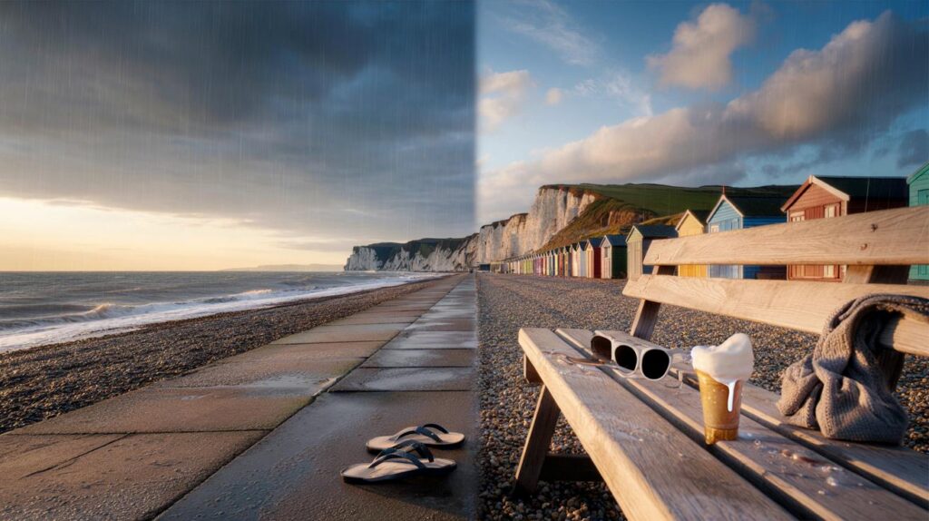
Sun-seekers get one last fling as a midweek warm-up tempts beach plans, just before cooler nights creep back.
A brief spell of late warmth returns to parts of England, then a sharp step down follows as Atlantic lows reassert control.
Warm spell returns for parts of England
After a summer stacked with heatwaves and hosepipe rules, the mercury will nudge the mid-20s again in eastern and south-eastern England. Weather maps point to highs of 23C to 25C on Wednesday 3 September, with sea-breezy coasts and sunny inland patches sharing the spoils. Expect a fresher start first thing, then a swift lift as sunshine breaks through late-morning cloud.
Highs near 25C are most likely in pockets of East Anglia, the Home Counties and greater London on Wednesday 3 September.
Counties most favoured for 23C to 25C include:
- Norfolk
- Suffolk
- Cambridgeshire
- Lincolnshire
- Kent
- Greater London
- Surrey
- Berkshire
- Hertfordshire
- Buckinghamshire
- Bedfordshire
- Northamptonshire
- Leicestershire
- Rutland
- Nottinghamshire
- East Riding of Yorkshire
Further north and west, temperatures sit closer to seasonal norms. Wales, Northern Ireland and much of Scotland keep a cooler feel, with more cloud and a higher chance of showers clipping in from the Atlantic.
How long will it last
The warm-up looks short-lived. It builds midweek, peaks for a day or so, then fades as fresher air undercuts from the west. Nights quickly trend cooler: many rural spots drop into single figures, while the chilliest hollows could see 3C to 5C late in the week, with patchy mist at dawn.
Autumn knocks: a sharp cool-down for many
Low pressure edges in to start September’s first full week. That pattern spells changeable days, brisk onshore winds in the west and north-west, and a mix of bright spells and showers. Bands of heavy rain are set to pivot across parts of the UK, especially near western hills where totals mount fastest. Where downpours line up under colder air aloft, hail and a rumble of thunder are possible.
Low pressure returns, bringing bands of heavy rain, isolated thunderstorms and brisk winds, especially in the west.
As fronts clear, colder air follows. Afternoon highs slide several degrees below the midweek peak, and evening temperatures tumble quickly after sunset. On higher ground in Scotland and northern England, a nip in the air arrives early, with wind chill on exposed fells. Urban centres stay milder but still feel the step down, particularly under clear skies overnight.
What this summer’s numbers say
Provisional figures suggest the season just ended may rank as the warmest on record for the UK, with a mean near 16.13C based on data to 28 August. If verified, that would push 2018 (15.76C) into second place, after an era of repeated warm standouts: 2006 (15.75C), 2003 (15.74C), 2022 (15.71C) and 1976 (15.70C). The striking pattern is the recent clustering of hot summers, with four of the top five since 2000.
Four distinct heatwaves shaped daily life this year, from beach gridlock to parched lawns. Parts of England faced hosepipe bans and drought warnings, while farmers juggled irrigation and grazing. This midweek spike to 25C fits the wider theme: late-summer warmth is lingering longer, before Atlantic systems flip the switch.
Five-day outlook at a glance
| Day | South and east England | Midlands | North of England | Wales, NI, Scotland | Headline |
|---|---|---|---|---|---|
| Wed 3 Sep | 23–25C, sunny spells, light breezes | 21–23C, bright, brief showers later | 17–21C, mixed cloud and sunny breaks | 15–19C, showers, breezy in west | Late warmth for the east |
| Thu 4 Sep | 20–23C, more cloud, showers late | 18–21C, scattered showers | 16–19C, showers and sunny intervals | 14–18C, heavy showers, gusty | Change sets in from the west |
| Fri 5 Sep | 18–21C, showers, brisk winds on coasts | 16–19C, showers, cooler | 14–18C, showers, some heavy | 12–17C, bands of rain, hill hail risk | Cooler, unsettled |
| Sat 6 Sep | 17–20C, sunny spells, a few showers | 15–18C, mixed, cooler nights | 13–17C, windy near coasts | 11–16C, showers and longer spells of rain | Seasonal with a nip after dark |
| Sun 7 Sep | 17–19C, brighter, isolated showers | 15–18C, drier, cool morning | 13–16C, a few showers | 10–15C, scattered showers, sunny breaks | Quieter but cool |
What it means for your plans
- Commuting: Midweek heat could lift track temperatures and raise glare on east–west routes; carry water and allow a few extra minutes.
- Health: UV still bites in strong midday sunshine; sun protection helps, even in September.
- Sport and leisure: Wednesday looks best for an after-work park run or beach trip in the east; check radar if you’re west of the Pennines from Thursday.
- Gardening: Warmth aids late blooms midweek, then cooler, damp air increases mildew risk; thin crowded plants and water early to reduce foliar wetness overnight.
- Home energy: Overnight lows near 3C in rural spots can trigger heating timers; a 1°C drop indoors can add noticeable boiler run-time—review schedules.
Why the flip happens
The midweek lift stems from a brief ridge of high pressure, allowing sunshine to build warmth over land. By late week, the jet stream dips and guides a deepening Atlantic trough towards the UK. That shift pulls in cooler, moist maritime air, energising showers where they meet leftover warmth. A 50–100 mile wobble in frontal position can swing outcomes locally between a soaking and a largely dry afternoon.
Spotlight on the east
East Anglia and the south-east benefit most from shelter and a gentle offshore flow on Wednesday. Inland towns sit 1–3C higher than immediate coasts, where a sea breeze trims peak readings. Air quality trends moderate; pollen drops from summer highs but grass and weed counts can still irritate during sunny spells.
Extra context and practical pointers
Short early-autumn warm spells are common in a maritime climate. The unusual part is how frequently they now follow summers at or near record heat. Many meteorologists point to long-term warming as the backdrop, which nudges baselines higher and loads the dice for late spikes.
If your area slides to 3C overnight, condensation becomes a nuisance in bathrooms and bedrooms. Crack a window for a short purge after showers, and keep furniture a few centimetres off external walls to improve airflow. Cyclists and early dog walkers should expect dewy pavements and thicker mist in river valleys just before sunrise.
Plan for two seasons in one week: light layers for midweek warmth, then a waterproof and a warmer jumper by Friday.


Beach on Wednesday, blankets by Friday—classic UK!