Radiators cough to life as daylight shrinks. Across Britain, families juggle layers, school runs and energy costs, wondering what’s coming.
The UK’s first steer on winter 2025/2026 points to fewer shocks and more routine cold. Early Met Office guidance suggests a season leaning towards near-normal conditions, with some mild spells possible, yet with the usual regional quirks that make planning tricky.
What the Met Office says now
The Met Office’s latest three‑month outlook, covering October to December 2025, nudges expectations towards a gentler start to winter than many remember from recent years. It outlines a greater chance of temperatures sitting close to the seasonal norm, and a smaller, still notable chance of a broadly mild feel.
Forecasters assign roughly a 55% chance of temperatures near average, and a 30% chance of a mild flavour in the run‑up to Christmas.
High pressure looks set to park over or near the UK at times. That usually keeps many areas settled and drier, with chilly nights and clearer skies. It can also trap cool air near the surface, so fog and frosts can still bite even when rain stays away. Rainfall signals remain mixed, as small shifts in pressure patterns can quickly tip some regions from dry to damp.
Odds of average versus mild
“Average” does not mean warm. It points to the kind of late‑autumn and early‑winter cold that most households recognise: nippy school runs, scraping windscreens, and heating schedules creeping from occasional to routine. A “mild” outcome increases the odds of fewer lengthy cold spells, yet short sharp snaps can still cut through.
A milder season overall does not rule out a few bitter days or a brief northerly blast.
Regional split: 8°C south to 1°C Scotland
The early‑season temperature gap across the country remains stark. Southern England trends milder by day, while upland and northern areas feel the chill sooner, especially at night.
Guidance points to around 8°C in the south over the period, while some parts of Scotland may dip close to 1°C.
That spread will shape how you heat your home, when you set timers, and how many layers you send the kids out in. Coastal communities often enjoy a softer edge to the cold on onshore winds, while inland valleys can trap frost overnight.
Snow prospects and early cold snaps
Stories of early snow swirls have already surfaced. The Met Office has pushed back, saying no widespread snow is on the cards for Scotland or northern England by late October. That doesn’t lock out hill flurries later in November or December, but it does lower the odds of an early‑term shutdown for schools and roads.
No widespread snow flagged for northern England or Scotland by the end of October, with high pressure often keeping things settled.
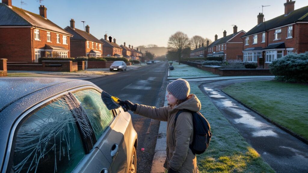
Watch for radiative frosts under clear skies. These can turn damp pavements and untreated B‑roads treacherous by dawn, even on “quiet” weather days.
Temperatures month by month
Average UK temperatures for the early winter period show the seasonal step‑down into December:
- October: 9.73°C
- November: 6.48°C
- December: 4.20°C
Local weather will vary. Urban heat islands can hold a degree or two overnight, while rural dips run colder. Expect wind direction to add spice: a brief Arctic northerly still knocks the numbers down, even if the broader pattern leans steady.
At a glance: the forecast in figures
| Metric | Value | What it means for you |
|---|---|---|
| Chance of near‑average temperatures | ~55% | Plan for familiar cold, not a deep freeze by default. |
| Chance of a mild outcome | ~30% | Fewer long cold spells likely, but keep hats and gloves handy. |
| Southern England seasonal guide | ~8°C | Cool days, chilly nights; layers over heavy winter coats early on. |
| Some Scottish locations | ~1°C | Frequent frosts; watch black ice and set heating timers sooner. |
What this means for your home and wallet
A steadier early winter can help households pace their energy use. Rather than cranking the thermostat for long stretches, target warmth where you sit and sleep. Focus on quick wins in draught control and heat retention.
- Shut heavy curtains at dusk and close internal doors to trap heat in lived‑in rooms.
- Use timer boosts of 30–60 minutes in the morning and evening to match your routine.
- Seal letterboxes and keyholes, and fit simple draught excluders along skirting gaps.
- Layer clothing: thin thermal base, mid‑layer fleece, windproof shell for school runs.
- Air the home briefly at midday on dry days to reduce condensation and damp chills.
High pressure often brings clear, calm nights. Homes then lose heat faster through windows and poorly insulated lofts. A basic loft top‑up and lined curtains can make a visible difference on those glass‑frost mornings.
Travel, schools and the daily routine
Morning frosts and fog threaten disruption more than heavy snow in this pattern. Leave extra time for buses and trains on still, cold mornings. Pack a small torch for late‑afternoon pick‑ups, as twilight arrives earlier and shaded pavements stay slick. Sports days and weekend fixtures may survive more often if the weather stays drier, but winter pitches can turn hard under back‑to‑back frosts.
What could change between now and January
Seasonal drivers, such as the North Atlantic Oscillation, decide where high pressure parks and whether the UK taps chilly continental air or milder Atlantic flows. Those swings can flip the feel of a fortnight. Confidence drops with lead time, so keep an eye on week‑ahead updates as December unfolds.
Short cold snaps remain on the table even in a “near‑average” season, especially if winds swing briefly north or east.
If a burst of colder air arrives, switch to shorter school‑run routes on minor roads with gritting gaps. Check tyre pressures as temperatures dip. Cold air also bumps up air‑quality issues on still days, so consider swapping a car trip for a brisk walk when feasible.
Extra context to help you plan
High pressure brings calmer weather, fewer storms and more sunshine hours. The trade‑off comes at night: skies clear, frost forms, and untreated surfaces glaze over. That pattern suits families who rely on weekend sport and outdoor clubs, but it asks for vigilance on early starts and late returns.
If you like a practical rule of thumb, try this: set your heating for shorter, smarter bursts while days sit in the mid‑single digits, add a thermal base layer when nighttime frosts return, and keep a cold‑snap kit ready by the door. A set of gloves, a hat, ice scraper and a reusable hand warmer turns an icy morning from hassle into routine.


55% near‑average sounds like hedging. If high pressure parks over us, won’t air quality and black ice get worse on those “quiet” mornings? The real risk feels like freezing pavements, not snow.
Guess I’ll keep the ice scraper by the door and the flip‑flops in the cupboard. Balanced, like the forecast 🙂