A sharp northerly turn is brewing. Cold air edges south as rain bands queue up and winds veer from the Arctic.
Forecasters now flag snowfall that could arrive heavier than early signals suggested, with fast-building cover most likely in Scotland.
What the latest models show
High-resolution maps point towards a wintry burst centred on the Scottish Highlands around 21 October, with signals building from mid to late month. Guidance derived from the GFS model, visualised by WXCharts using MetDesk data, highlights a window from early morning through midday when precipitation turns to snow above modest elevations.
Up to 10cm (around four inches) could quickly settle across exposed Highland slopes between 6am and noon on 21 October.
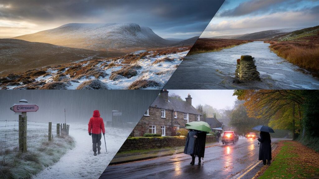
Edinburgh and the Lothians sit close to the southern edge of this chill. Short-lived flurries are possible as the colder air noses south. North Wales also features as a late-month candidate for the first dusting of the season on the highest peaks, while northern England faces a different headache: persistent heavy rain.
The broader setup steers the change. A strengthening dome of high pressure looks set to take charge across and beyond the UK, potentially centring over the Norwegian Sea for a time. That position encourages a north-easterly feed into eastern counties, increasing cloud and the chance of coastal showers while keeping many inland areas settled.
Who feels it and when
Scotland: Highlands first in line
Cold air undercuts bands of moisture moving south across the far north. Orographic lift over the Cairngorms and surrounding ranges squeezes extra precipitation from the air, improving snowfall prospects even where the freezing level sits just above the glens. A few heavier pulses could flip rain to wet snow down to 200–300 metres for a time.
First autumn flakes look most convincing across the Cairngorms National Park, with the best chance of cover on windward slopes.
Edinburgh and the central belt
As the morning band slides south, marginal wet snow can mix in over the Pentlands and nearby high ground. Any city-level slush would be fleeting. Colder gusts, splashes of rain and a wind chill that bites will be the more noticeable features for most commuters.
North Wales: late‑month risk
Signals for a late-October brush with wintry precipitation pop up over Snowdonia, mainly above 500–600 metres. Short bursts could whiten paths on the Glyderau and Yr Wyddfa, especially during night-time cooling. Lower levels remain damp rather than white.
Northern England: rain-drenched instead
While the far north turns wintry, northern England sits under long spells of rain. Saturated ground and gusty easterlies could slow traffic, lift river levels and test drains. Keep an eye on local advisories for surface water hazards.
| Region | Expected conditions | Likely timing | Elevation most at risk |
|---|---|---|---|
| Scottish Highlands | Frequent snow showers; 5–10cm in places; drifts on exposed tops | 21 Oct, 6am–noon | Above 200–300m, highest risk above 400m |
| Cairngorms National Park | Heavier bursts; rapid cover during squalls | Morning of 21 Oct | Above 300m, deepest cover on plateau |
| Edinburgh and Lothians | Rain with wet flakes on hills; brief slush | Late morning to afternoon, 21 Oct | Above 150–200m |
| North Wales high tops | Late‑month flurries; light covering | Late October | Above 500–600m |
| Northern England | Torrential rain; localised flooding risk | Through the week | All elevations |
Why the snow risk has jumped
The shift comes from a classic early‑season battle between residual warmth at the surface and a colder airstream aloft. As high pressure firms up to the north, it funnels air from the Arctic quadrants across the North Sea. That air cools and picks up moisture, then hits Scottish terrain and rises. Rising air cools further, turning showers wintry where the wet‑bulb temperature dips near freezing.
Small changes in wind direction matter. A fraction more east in the flow favours North Sea showers into eastern Scotland and north-east England. A nudge more north swings the focus onto the Highlands and Grampians. Model spreads this week lean towards a northerly‑north‑easterly, which suits Highland snowfall in short, sharp bursts.
Marginal setups can still lay down a quick 2–4 inches when showers align and hills squeeze extra moisture from the flow.
Travel and daily life: what to prepare for
- Allow extra time on routes over higher passes in the Highlands; slushy stretches can form quickly during squalls.
- Expect spray and standing water across northern England; plan detours where drains often back up.
- Hikers should pack winter layers and traction for high tops; wind chill can tumble below zero on plateaux.
- Keep an eye on gritters’ schedules in affected councils; early-season treatments often start with marginal events.
- Rail operators may run cautionary speed restrictions on exposed Highland lines during heavy bursts.
What to watch over the next 5–7 days
Forecasts will sharpen as the high positions and the exact wind angle settle. The following markers help track confidence:
- Freezing level dropping towards 500–700 metres across northern Scotland during the morning of 21 October.
- Dew points near or below 0C on Highland summits, supporting settling snow during heavier pulses.
- Convergence lines on charts from Moray to the Cairngorms, signalling repeated showers over the same ground.
- Persistent rain bands aligned over northern England, raising runoff and river response risks.
- Cloudier, cooler north-easterlies feeding into eastern England with occasional coastal showers.
How four inches can fall so fast
Short, vigorous showers in cold maritime air flip to snow as they ride uphill. Each burst may last only minutes, but repeated cells can stack up accumulations. Where gusts cross ridges, drifting adds depth in lee pockets even when nearby ground shows less. Early in the season, road surfaces hold warmth, so low routes stay wet unless snowfall intensifies. High tracks and car parks on shaded aspects accumulate first and hold cover longer.
Extra context that helps you plan
This type of October snow rarely sticks around for long at mid‑levels. Sunshine quickly softens any crust outside shaded corries. For hillwalkers and photographers, early flurries bring dramatic contrasts against autumn colours, but weak October light and low sun angles reduce melting on north‑facing slopes. That raises the chance of icy patches the following morning where slush refreezes.
For farmers and gardeners in northern counties, a briefer cold snap can still nip late growth. Move tender pots under cover and clear leaves from drains before the heavier rain arrives further south. If the high does anchor over the Norwegian Sea into next week, expect a drier, cooler pattern for many, a cloudier feel near North Sea coasts, and only isolated showers drifting inland on the breeze.


Are these model runs still holding today? Is the freezing level really dipping to 500–700 metres over the Highlands on the 21st, or has guidance shifted since this was posted?