Temperatures slip, winds swing westerly, and weather maps turn purple as Britain braces for the first proper hint of winter.
Fresh model runs point to a wintry turn within ten days, with the first meaningful flakes targeted at Scotland’s highest ground. Forecast charts show a focused burst, while a broader shuffle in pressure patterns nudges chillier air and unsettled spells across the country.
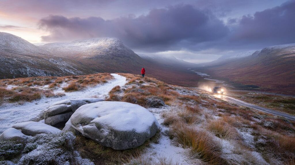
What the latest maps show
Weather visualisations from WX Charts highlight a patch of intense snowfall signal over the Cairngorms on Sunday 12 October. The model snapshot points to 7.32cm — around 2.8 inches — falling over the mountains during the day, with showers feeding in on a brisk flow from the Atlantic.
Model guidance indicates around 7.3cm of snow over parts of the Cairngorms on Sunday 12 October, focused on high ground.
This is an early-season signal, not a countrywide snowstorm. Lower levels are more likely to see cold rain or sleet. The emphasis remains on upland routes and summits in northern Scotland, where temperatures tip close to freezing during heavier bursts.
Timing at a glance
- Window: 7–16 October, with the clearest snow signal centred on Sunday 12 October
- Where: Highest ground in the Scottish Highlands, especially the Cairngorms
- Elsewhere: Wintry showers possible on the highest peaks of northern England; rain for most
- Confidence: Medium for Scottish uplands, low for widespread low-level snow
Met Office signals behind the chill
The medium-range pattern keeps a broadly westerly flow to start, which favours relatively mild nights but frequent Atlantic fronts. Northern and western areas take the wettest and windiest spells, while many eastern districts stay somewhat drier between systems.
Into the second weekend of the period, guidance suggests higher pressure to the west or southwest of the UK and lower pressure settling to the east. That shift can bend bands of rain into eastern counties and draw in slightly cooler air, especially where winds swing more northwesterly.
As pressure builds to the west and lowers to the east, cooler air can edge in, briefly lowering snow levels over northern high ground.
Where you could see snow first
Elevation is the key. Early October snow usually sticks above 700–900 metres, with any low-level flakes short-lived. Here is the current snapshot based on model output and typical early-season behaviour:
| Region | Elevation most at risk | Likelihood | Modelled or typical amount |
|---|---|---|---|
| Cairngorms (Highlands) | 800–1,200m | Moderate | Up to 7.3cm on Sunday 12 October |
| West Highlands and Nevis range | 900–1,300m | Low to moderate | Dusting to a few centimetres in heavier showers |
| Northern Pennines | 700–900m | Low | Sleet or a brief dusting on tops |
| North York Moors | 400–500m | Low | Cold rain most likely; fleeting sleet possible |
| Snowdonia | 900–1,000m | Low | Wintry showers possible on the highest summits only |
How much could fall where you live?
The headline 2.8 inches applies to exposed Scottish peaks. Most people will see rain, brisk winds and a pronounced chill in the air rather than accumulating snow. Ground temperatures at low levels remain relatively warm after a mild start to October, so any wet flakes would melt quickly outside the mountains.
Snow lines can wobble during showers. A heavy burst can drag colder air down and briefly lower the freezing level, allowing slushy coverings on grassy surfaces above 700–800 metres. Night-time offers the best chance of settling, especially if skies clear between showers.
Travel and infrastructure
Hill passes and exposed routes are the first to feel wintry weather. Gritting crews may treat the highest stretches if temperatures dip near freezing. Strong gusts on ridgelines can cause brief whiteout conditions during showers, reducing visibility for walkers and drivers on mountain roads.
Short, sharp downpours could also spark surface water on lower routes, mixing with fallen leaves to create slippery patches. Power issues are uncommon at this stage of the season but cannot be ruled out where wind and wet snow combine on remote lines.
What you should do now
- Check mountain forecasts and webcams if you plan upland travel or hiking this weekend.
- Carry warm layers, waterproofs and a headtorch; early dusk and wind chill can catch people out.
- Allow extra time on Highland and upland routes; expect sudden drops in visibility in showers.
- Secure outdoor items at home; squally gusts can coincide with passing fronts.
- If you live near higher routes, expect gritting trucks overnight as temperatures dip.
Key numbers to watch
- 7.3cm: modelled snowfall over the Cairngorms on Sunday 12 October
- 10 days: typical window for the cooler push signalled by current guidance
- 700–900m: likely snow line for any settling accumulations
- Highlands first: best chance of seeing lying snow this side of mid-October
Why early October snow is possible
Autumn often brings energetic Atlantic systems. When a northwesterly surge follows a frontal passage, it can pull colder air across the UK. Add strong uplift over mountains, and showers flip from rain to wet snow on the highest ground. Because soils retain warmth from summer, the window for settling is short, mainly overnight and above the tree line.
As the season advances, persistent high pressure to the west and lower pressure to the east would favour further cool incursions. That setup can shift the wettest weather into the North Sea side while giving western hills brighter spells between showers.
What to watch next
Focus on how far south the cooler air digs by the weekend, and whether the wind turns more northwesterly. A slightly colder profile would lower the snow line by 100–200 metres, lifting the chance of transient coverings on more summits. A milder track would confine snow to the highest Cairngorm plateaus with rain elsewhere.
For hikers and drivers, the practical takeaway is simple: expect a raw feel, gusty spells, and a real risk of wintry conditions on Scotland’s highest ground. Keep plans flexible and check updated local forecasts as the weekend approaches.


Is that 7.3 cm strictly for the Cairngorms above ~800–900 metres, or could brief bursts bring a slushy cover to the Cheviots/Northern Pennines too? For towns at 200–300 m, are we basically looking at cold rain with a brisk westerly?