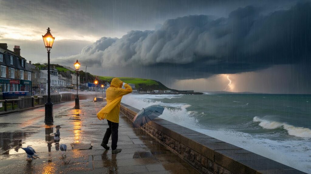
Rain has returned, the breeze is stiffening and plans feel fragile, as an Atlantic system gathers strength far to the west.
Met Office forecasters are watching a deepening North Atlantic low that could shape the weekend. Confidence on the exact path stays low, but the weather pattern points to a lively spell with the risk of a named storm if impacts climb.
Met Office verdict and the path to a storm name
The first name on this season’s official UK and Ireland storm list is Amy, chosen from thousands of public suggestions. That name will only be used when a storm is expected to bring medium or high impacts. In practice, forecasters attach a name when they anticipate issuing strong wind or rain warnings that may disrupt travel and day‑to‑day life.
As of midweek, the Met Office says conditions later in the weekend could turn wet and windy enough for widespread disruption, with the greatest risk in northern parts of the UK. The agency has not named a storm yet, and emphasises that the precise track and timing may shift as new model runs arrive.
The current signal: heavy rain and strong winds look increasingly likely late on Saturday into Sunday and possibly Monday, but the threshold for naming remains under review.
Deputy chief meteorologist Tom Crabtree notes that a deepening low over the North Atlantic could bring impactful weather to the UK, especially later Sunday into Monday, while stressing that confidence in exact impacts is still developing. Teams are comparing multiple computer models and will update guidance as the picture sharpens.
How the weekend could play out
After a changeable week, Monday and Tuesday offer the most usable weather, before conditions slide downhill from Wednesday. Showers become more frequent, winds freshen, and longer spells of rain nudge in from the west.
Saturday brings a familiar British mix of sunshine and showers. Southern counties face the risk of a more organised pulse of rain pushing through. By Saturday evening, the risk of heavy rain, thunderstorms and strengthening winds grows, with the more significant spell most likely to cross into Sunday.
| Day | Headline | What to expect |
|---|---|---|
| Monday | Best of the week | Brighter spells, a few showers, lighter winds for many. |
| Tuesday | Still usable | Sunny intervals, scattered showers; gentle to moderate breeze. |
| Wednesday | Turning unsettled | More frequent showers, freshening south‑westerly winds. |
| Thursday | Wet spells building | Bands of rain moving east, gustier along coasts and hills. |
| Friday | Blustery showers | On‑and‑off downpours; temperatures near seasonal; poor conditions at times. |
| Saturday | Sunshine and showers | Heavier rain risk for the south later; winds starting to pick up. |
| Saturday night to Sunday | Risk of impactful weather | Heavy rain, possible thunderstorms, and strong winds; watch for updates. |
Who stands to see the worst
Early signals favour the north for the strongest winds, with exposed coasts and higher routes most vulnerable to gusts. Western hills often see the highest rain totals when Atlantic systems deepen. Southern areas could catch a spell of heavier rain on Saturday before the main pulse pushes north and east.
Best window for outdoor plans: Monday and Tuesday. From Wednesday, each day carries a higher chance of persistent rain and stronger winds.
Why a deepening Atlantic low matters
Rapidly falling pressure over the ocean tightens the pressure gradient. That tight gradient drives stronger winds, and it also encourages active weather fronts that can deliver prolonged rain. At this time of year, the jet stream often re‑energises after summer, helping lows deepen as they approach the British Isles. Small shifts of 100–200 miles in the track can change who sees peak gusts or the heaviest rainfall, which is why the Met Office is holding off on any storm name for now.
Embedded thunderstorms remain possible when warm, humid air meets the advancing fronts. Lightning, short‑lived torrential downpours and sudden gusts can pop up on the leading edge of the rain band, especially Saturday night into early Sunday.
Recent rain primes the ground
The soil is already wet. Official figures show the UK just had its wettest week in seven months. The North West, South East and South West each picked up more than 35 mm between 27 August and 2 September. That matters because saturated ground sheds water more quickly, raising the chance of surface water on roads and fast‑responding streams reacting to further heavy rain.
What you can do now
- Check gutters and street drains near your home and clear leaves where safe.
- Secure garden furniture, bins and trampolines ahead of a possible windy spell.
- Plan travel with flexibility: allow extra time, especially for cross‑country rail and exposed routes.
- Charge phones and power banks; pack torches if you live in a rural, overhead‑line area.
- Drivers: slow on wet roads, watch for standing water, and be ready for side winds on bridges.
Key numbers at a glance
These figures reflect typical outcomes in this kind of set‑up, and will be refined by Met Office updates:
- Gusts: 50–60 mph along some coasts and high ground; 35–45 mph inland where the core of the low tracks closer.
- Rainfall: 20–40 mm widely under active fronts; 50 mm or more possible on western hills if bands stall.
- Thunder risk: greatest Saturday night into Sunday morning, with brief torrential bursts.
- Recent baseline: 35 mm+ fell across parts of the North West, South East and South West last week.
How naming works and what to watch next
Met Office, Met Éireann and the Royal Netherlands Meteorological Institute jointly name storms to improve public awareness. A name arrives when forecasters expect impactful wind or rain that warrants stronger warnings. No name has been issued yet for the approaching system. The signal will strengthen or weaken as fresh data lands, especially from Thursday’s trans‑Atlantic observations feeding into Friday’s model runs.
Keep an eye on the forecast focus: if guidance shifts the low farther north into Scotland, northern and western districts would bear the brunt of the wind. A track farther south would push more rain into central and southern England while tempering peak gusts. Small deviations matter, so expect adjustments to timings and regional emphasis.
Extra context for the weekend
Sports fixtures, festivals and outdoor markets face the classic late‑summer trade‑off: Saturday remains workable for many, especially earlier in the day, but contingency plans help if the evening turns wet. Campers and coastal walkers should check local updates on tide times and wind warnings. Mountain routes may see very poor visibility and sudden squally showers as the frontal rain arrives.
Householders in flood‑prone spots can stage simple simulations at home: if you placed a plank to guide water away from a doorway, would it seal properly? Do sandbags sit where you can reach them within minutes? These small checks reduce scrambling if the heaviest band sets in overnight. Meanwhile, gardeners might use the wetter spell to mulch beds and protect soil from compaction, reducing runoff in future downpours.


Another “could‑be‑named” storm… feels like the bar keeps moving. If confidence on the track is low, why lead with 60mph gusts? I’d prefer probabilities and ranges over clicky hedlines.
Securing the bin, the chairs, and the trampoline—again. The Trampo‑calypse rides at dawn.