After a blazing summer, September brings a tug‑of‑war between cooler Atlantic air and lingering warmth, keeping plans on a knife‑edge.
Many of you are asking whether sandals or umbrellas win this month. Early guidance points to mixed skies, short warm bursts, and a few lively downpours.
What we know so far
After four distinct heatwaves this summer, talk of a late “Indian summer” has swirled. Current Met Office guidance points a different way. Temperatures look set to top out in the low 20s Celsius for most, with the south‑east closest to 23–25C on the balmiest days. The broader picture leans changeable, with showers pulsing through and longer spells of rain at times, especially between 4 and 13 September.
Expect highs mostly in the 18–22C bracket, brief lifts to 23–25C in the south‑east, and several wet interludes driven in from the Atlantic.
The headline outlook
Temperature: close to seasonal, occasionally cooler
Daytime values should sit close to, or a touch under, the September norm. Many towns will see 18–21C in the first half, nudging 22–23C on brighter days. Nights trend fresher, with 9–13C typical, and a few rural dips to single figures under clear skies. Any 25C spike looks short‑lived and confined to the south or east.
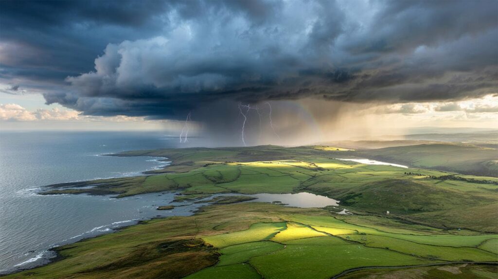
Rain and storms: frequent showers, western bias
Repeated Atlantic fronts appear set to march in, breaking up better spells. Western coasts and hills hold the higher risk of heavy downpours and gusty squalls. Embedded thunder can’t be ruled out where sunshine heats the ground ahead of incoming bands, particularly in the north‑west and along the Welsh coast.
Between 4 and 13 September, the pattern trends unsettled: showers bunch together, rainbands linger, and the west feels the strongest winds.
Wind: breezy phases, brief lulls
Blustery days look most likely near western shores and higher ground, with gusts occasionally 35–45 mph under stronger pulses. Inland stays breezy rather than windy. Short calmer windows follow each frontal passage before the next system approaches.
Week‑by‑week hints
- 1–3 September: mixed start. Sunny breaks, scattered showers, 18–22C. Fresher nights.
- 4–9 September: more unsettled. Longer rain spells, brisk winds in the west, isolated thunder. Highs 17–21C.
- 10–13 September: frequent showers, occasional heavy bursts. Brief brighter gaps. 16–20C widely.
- Mid‑month window: a short, drier interlude possible, particularly in the east and south‑east, nudging 22–24C for a day or two.
Regional snapshot: 4–13 September
| Region | Likely daytime highs | Rain and wind | Thunder chance |
|---|---|---|---|
| South‑east and London | 19–23C, odd 24–25C peak | Showers with brief dry spells; moderate breezes | Low to moderate, mainly after sunny breaks |
| South‑west | 18–21C | Frequent showers, longer rain; gusts 35–45 mph on coasts | Moderate, especially near fronts |
| Wales | 17–20C | Changeable with bands of heavy rain in the west | Moderate |
| Midlands | 17–21C | Showery days, brighter intervals; breezy at times | Low to moderate |
| North‑west England | 16–19C | Unsettled, frequent rain, stronger gusts near coasts | Moderate |
| North‑east England | 16–19C | Showers spreading from west; drier pockets near the coast | Low to moderate |
| Scotland | 14–18C, cooler Highlands | Bands of rain; windy over hills and western isles | Moderate |
| Northern Ireland | 16–19C | Frequent showers, occasional heavy bursts; breezy | Moderate |
Will there be another heatwave?
The ingredients for a broad, prolonged heatwave look scarce. Warm plumes from the near continent may throw the south‑east a day or two near the mid‑20s, but the Atlantic train keeps barging in. Sustained 30C values look highly unlikely under this pattern.
What this means for your week
Commuting and school runs
Carry a compact umbrella and swap heavy coats for a light waterproof. Roads will turn greasy after dry spells, so build a few minutes into your plan on the first wet morning. Early starts may feel crisp, so a thin layer helps at bus stops and platforms.
Events and sport
For weekend fixtures, western grounds face higher postponement risk. Have a wet‑weather plan for kit and spectators. East and south‑east venues stand a better chance of playable windows, especially late morning into early afternoon before showers reorganise.
Gardens and green spaces
Recent heat has left some soils hydrophobic. When rain returns, it can run off fast. Loosen topsoil in beds, mulch where possible, and water deeply but less often during dry breaks to reduce stress on shrubs. Keep an eye on grass growth: cooler, showery conditions can spark a quick rebound.
Why it feels so changeable
September often straddles two regimes. This year, comparatively cool Atlantic air masses are undercutting late‑season warmth over the near continent. That tug sets up pressure contrasts, driving fronts that deliver pulses of rain. Brief ridges of high pressure follow, giving clearer slots before the next system arrives. The west, more exposed to incoming flow, catches the brunt; the east benefits when rainbands fragment over high ground.
Risks to watch
- Short, sharp downpours: localised surface water on urban roads and underpasses.
- Gusty squalls: temporary crosswinds on bridges and coastal routes.
- Lightning in convective showers: brief disruption to outdoor events.
- Grassland fire risk: lower than in August, yet still possible after longer dry breaks, especially around London’s outer parks.
Opportunities amid the grey
Air quality generally improves under Atlantic flow, helpful for runners and cyclists. Cooler nights also lift sleep quality after a sultry August. If you’re chasing light, golden hours often appear in the late afternoon behind a passing band of showers. Photographers can use a polariser to punch through glare and capture rain‑washed streets.
Planning tools you can use
Two‑step check for outdoor plans
- Step 1: look for timing of frontal bands over your area within a 3–6 hour window.
- Step 2: scan radar for gaps behind the main band; those gaps frequently last 45–120 minutes.
Temperature budgeting at home
With highs near 20C and cooler nights, many households can delay full heating by using zoned warmth in evening rooms only. A 1‑degree setback on thermostats during shoulder months can trim usage while keeping comfort intact. On clearer nights, close curtains at dusk to hold onto daytime gains.
Bottom line: think layers, plan around pulses of rain, and expect just one or two short warmer bursts rather than a late‑season blaze.


Planning a campsite weekend in Snowdonia 9–10 Sept—are those “frequent showers and gusts 35–45 mph on coasts” likely to push inland into the valleys, or do we just get breezy with brief lulls? Trying to decide tents vs pods.
So the September uniform is: sandals at lunch, waterproof by tea time, and a brolly in the backpack at all times? 🙂